IMAGES TAKEN NEAR TO
Coombe Road, WOTTON-UNDER-EDGE, GL12 7LU
Introduction
This page details the photographs taken nearby to Coombe Road, GL12 7LU by members of the Geograph project.
The Geograph project started in 2005 with the aim of publishing, organising and preserving representative images for every square kilometre of Great Britain, Ireland and the Isle of Man.

There are currently over 7.5m images from over14,400 individuals and you can help contribute to the project by visiting https://www.geograph.org.uk
Image Map
Images are licensed for reuse under creativecommons.org/licenses/by-sa/2.0
Notes
- Clicking on the map will re-center to the selected point.
- The higher the marker number, the further away the image location is from the centre of the postcode.
Image Listing (195 Images Found)
Images are licensed for reuse under creativecommons.org/licenses/by-sa/2.0
Image
Details
Distance
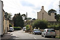
1
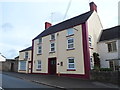
Former Salutation Inn, Wotton-under-Edge
The former pub in Coombe Road is in residential use.
Image: © Jaggery
Taken: 28 Oct 2012
0.01 miles
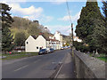
3

The Cotswold Way at Valley Road, Wotton-under-Edge
The Cotswold Way, day four 11:11am
Image: © Ian S
Taken: 20 Apr 2013
0.01 miles
4

The Cotswold Way at Valley Road, Wotton-under-Edge
The Cotswold Way, day four 11:11am
Image: © Ian S
Taken: 20 Apr 2013
0.01 miles
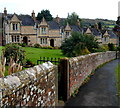
5
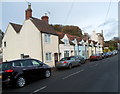
Coombe Road houses, Wotton-under-Edge
Viewed from the corner of Manor Lane.
Image: © Jaggery
Taken: 28 Oct 2012
0.02 miles
6
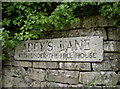
Adey's Lane
Including an unusual reference to a certain house.
Image: © Neil Owen
Taken: 2 Aug 2014
0.02 miles
8
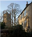
House and church tower, Wotton-Under-Edge
From the Cotswold Way as it climbs Valley Road, a glimpse past a Cotswold stone building of the church tower of Image The tower straddles a gridline; the sunlit face is in this square.
Image: © Derek Harper
Taken: 2 Jan 2010
0.03 miles
9
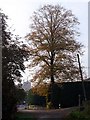
Valley Road and St Mary the Virgin
Looking along Valley Road, the church of St Mary the Virgin can just be seen in the distance. The tower dates from the late 14th century.
Image: © Linda Bailey
Taken: 5 Nov 2006
0.03 miles
10
Five of ten Bearpacker almshouses, Wotton-under-Edge
See http://www.geograph.org.uk/photo/3811137 for a view of the other five and details of the inscription.
Image: © Jaggery
Taken: 28 Oct 2012
0.04 miles