IMAGES TAKEN NEAR TO
Shepherds Leaze, WOTTON-UNDER-EDGE, GL12 7LH
Introduction
This page details the photographs taken nearby to Shepherds Leaze, GL12 7LH by members of the Geograph project.
The Geograph project started in 2005 with the aim of publishing, organising and preserving representative images for every square kilometre of Great Britain, Ireland and the Isle of Man.

There are currently over 7.5m images from over14,400 individuals and you can help contribute to the project by visiting https://www.geograph.org.uk
Image Map
Images are licensed for reuse under creativecommons.org/licenses/by-sa/2.0
Notes
- Clicking on the map will re-center to the selected point.
- The higher the marker number, the further away the image location is from the centre of the postcode.
Image Listing (17 Images Found)
Images are licensed for reuse under creativecommons.org/licenses/by-sa/2.0
Image
Details
Distance
1
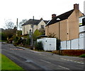
Wortley Road, Wotton-under-Edge
Viewed from near the corner of Water Lane and new houses. http://www.geograph.org.uk/photo/3732045
Image: © Jaggery
Taken: 28 Oct 2012
0.17 miles
2
New houses in Wotton-under-Edge
On the corner of Water Lane and Wortley Road, part of the Mill Brook development by Elan Homes.
Image: © Jaggery
Taken: 28 Oct 2012
0.18 miles
3
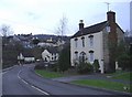
Dyers Brook House, Wotton-under-edge
At the south eastern entrance to the town centre.
Image: © Roger Cornfoot
Taken: 19 Feb 2007
0.19 miles
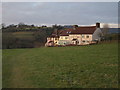
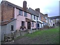
4
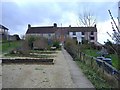
Brickfields
An interesting group of cottages, at the end of the Bearfields housing estate.
Image: © Roger Cornfoot
Taken: 19 Feb 2007
0.21 miles
5
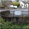
Depositing rubbish in this stream is forbidden, Wotton-under-Edge
The Wotton-under-Edge town council notice is on a fence alongside Dyers Brook.
Image: © Jaggery
Taken: 28 Oct 2012
0.21 miles
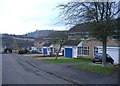
6
Brickfields, Wotton-Under-Edge
This view of Image is from footpath CWE/58/1 and shows fields on the far side of the little valley that runs through the town.
Image: © Derek Harper
Taken: 1 Jan 2010
0.22 miles
7
Bearlands, Wotton-under-edge
The town centre is just visible, on the hill in the distance.
Image: © Roger Cornfoot
Taken: 19 Feb 2007
0.22 miles
8
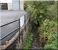
Dyers Brook, Wotton-under-Edge
Viewed from the street also named Dyers Brook.
Colour-Tech accident repair centre http://www.geograph.org.uk/photo/3732013 is on the left.
Image: © Jaggery
Taken: 28 Oct 2012
0.22 miles
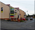
9
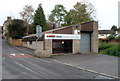
Colour-Tech accident repair centre, Wotton-under-Edge
Located in a street named Dyers Brook, alongside a brook http://www.geograph.org.uk/photo/3732024 of the same name.
Image: © Jaggery
Taken: 28 Oct 2012
0.22 miles
10
Brickfields
These cottages have a lovely view across the valley.
Image: © Roger Cornfoot
Taken: 19 Feb 2007
0.22 miles