IMAGES TAKEN NEAR TO
Court Orchard, WOTTON-UNDER-EDGE, GL12 7JE
Introduction
This page details the photographs taken nearby to Court Orchard, GL12 7JE by members of the Geograph project.
The Geograph project started in 2005 with the aim of publishing, organising and preserving representative images for every square kilometre of Great Britain, Ireland and the Isle of Man.

There are currently over 7.5m images from over14,400 individuals and you can help contribute to the project by visiting https://www.geograph.org.uk
Image Map
Images are licensed for reuse under creativecommons.org/licenses/by-sa/2.0
Notes
- Clicking on the map will re-center to the selected point.
- The higher the marker number, the further away the image location is from the centre of the postcode.
Image Listing (180 Images Found)
Images are licensed for reuse under creativecommons.org/licenses/by-sa/2.0
Image
Details
Distance
1
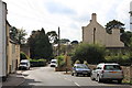
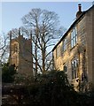
Valley Road and St Mary the Virgin
Looking along Valley Road, the church of St Mary the Virgin can just be seen in the distance. The tower dates from the late 14th century.
Image: © Linda Bailey
Taken: 5 Nov 2006
0.07 miles
2
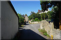
Valley Road, Wotton-under-Edge
An older part on the edge of the town.
Image: © Bill Boaden
Taken: 19 Jul 2016
0.07 miles
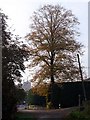
4

The Cotswold Way at Valley Road, Wotton-under-Edge
The Cotswold Way, day four 11:11am
Image: © Ian S
Taken: 20 Apr 2013
0.09 miles
5

The Cotswold Way at Valley Road, Wotton-under-Edge
The Cotswold Way, day four 11:11am
Image: © Ian S
Taken: 20 Apr 2013
0.09 miles
6
House and church tower, Wotton-Under-Edge
From the Cotswold Way as it climbs Valley Road, a glimpse past a Cotswold stone building of the church tower of Image The tower straddles a gridline; the sunlit face is in this square.
Image: © Derek Harper
Taken: 2 Jan 2010
0.10 miles
7
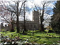
St Mary the Virgin, Wotton-Under-Edge
Largely C13. The tower was completed in C14.
Image: © Bikeboy
Taken: 8 Apr 2014
0.10 miles
8

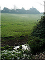
The Cotswold Way towards Holywell
The Cotswold Way, day four 11:13am
Image: © Ian S
Taken: 20 Apr 2013
0.10 miles
9
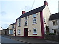
Former Salutation Inn, Wotton-under-Edge
The former pub in Coombe Road is in residential use.
Image: © Jaggery
Taken: 28 Oct 2012
0.10 miles