IMAGES TAKEN NEAR TO
Locombe Place, WOTTON-UNDER-EDGE, GL12 7HZ
Introduction
This page details the photographs taken nearby to Locombe Place, GL12 7HZ by members of the Geograph project.
The Geograph project started in 2005 with the aim of publishing, organising and preserving representative images for every square kilometre of Great Britain, Ireland and the Isle of Man.

There are currently over 7.5m images from over14,400 individuals and you can help contribute to the project by visiting https://www.geograph.org.uk
Image Map
Images are licensed for reuse under creativecommons.org/licenses/by-sa/2.0
Notes
- Clicking on the map will re-center to the selected point.
- The higher the marker number, the further away the image location is from the centre of the postcode.
Image Listing (6 Images Found)
Images are licensed for reuse under creativecommons.org/licenses/by-sa/2.0
Image
Details
Distance
1
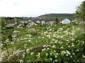
View over allotments in Wotton-under-Edge
allotments on the edge of the small Cotswold town of Wotton-under-Edge.
Image: © Philip Halling
Taken: 19 Apr 2017
0.13 miles
2
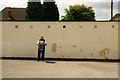
The lone drummer
A morris drummer at the Full Moon pub.
Image: © Jeff Tomlinson
Taken: 22 Jun 2008
0.17 miles
3
Full Moon Public House, Synwell, Wotton-under-Edge
Morris dancing at the pub.
Image: © Jeff Tomlinson
Taken: 22 Jun 2008
0.17 miles
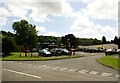
5
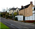
Wortley Road, Wotton-under-Edge
Viewed from near the corner of Water Lane and new houses. http://www.geograph.org.uk/photo/3732045
Image: © Jaggery
Taken: 28 Oct 2012
0.24 miles
6
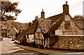
The Ram Inn (closed), Wotton Under Edge, Gloucestershire 2015
Former Pub, now private home, reputed to be among the most haunted buildings in England.
Image: © Ray Bird
Taken: 11 Sep 2015
0.25 miles