IMAGES TAKEN NEAR TO
Worlds End Lane, WOTTON-UNDER-EDGE, GL12 7HD
Introduction
This page details the photographs taken nearby to Worlds End Lane, GL12 7HD by members of the Geograph project.
The Geograph project started in 2005 with the aim of publishing, organising and preserving representative images for every square kilometre of Great Britain, Ireland and the Isle of Man.

There are currently over 7.5m images from over14,400 individuals and you can help contribute to the project by visiting https://www.geograph.org.uk
Image Map
Images are licensed for reuse under creativecommons.org/licenses/by-sa/2.0
Notes
- Clicking on the map will re-center to the selected point.
- The higher the marker number, the further away the image location is from the centre of the postcode.
Image Listing (4 Images Found)
Images are licensed for reuse under creativecommons.org/licenses/by-sa/2.0
Image
Details
Distance
1
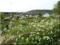
View over allotments in Wotton-under-Edge
allotments on the edge of the small Cotswold town of Wotton-under-Edge.
Image: © Philip Halling
Taken: 19 Apr 2017
0.11 miles
2
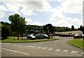
Full Moon Public House, Synwell, Wotton-under-Edge
Morris dancing at the pub.
Image: © Jeff Tomlinson
Taken: 22 Jun 2008
0.16 miles
3
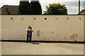
The lone drummer
A morris drummer at the Full Moon pub.
Image: © Jeff Tomlinson
Taken: 22 Jun 2008
0.16 miles
4
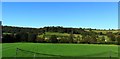
Synwell playing fields, Wotton-Under-Edge
This is the ground used by Wotton Rovers who play in the Gloucestershire Northern Senior League Division Two.
Image: © nick macneill
Taken: 14 Oct 2012
0.25 miles