IMAGES TAKEN NEAR TO
The Butts, WOTTON-UNDER-EDGE, GL12 7DS
Introduction
This page details the photographs taken nearby to The Butts, GL12 7DS by members of the Geograph project.
The Geograph project started in 2005 with the aim of publishing, organising and preserving representative images for every square kilometre of Great Britain, Ireland and the Isle of Man.

There are currently over 7.5m images from over14,400 individuals and you can help contribute to the project by visiting https://www.geograph.org.uk
Image Map
Images are licensed for reuse under creativecommons.org/licenses/by-sa/2.0
Notes
- Clicking on the map will re-center to the selected point.
- The higher the marker number, the further away the image location is from the centre of the postcode.
Image Listing (105 Images Found)
Images are licensed for reuse under creativecommons.org/licenses/by-sa/2.0
Image
Details
Distance
1
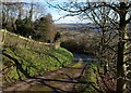
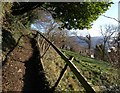
Drive on Wotton Hill
The road from Hillside Cottage down into Wotton-Under-Edge, crossed here by the Cotswold Way.
Image: © Derek Harper
Taken: 2 Jan 2010
0.04 miles
2
Heading towards Wotton-under-Edge
The Cotswold Way, day four 10:52am
Image: © Ian S
Taken: 20 Apr 2013
0.05 miles
3
Walking down Wotton Hill
The Cotswold Way, day four 10:51am
Image: © Ian S
Taken: 20 Apr 2013
0.05 miles
5
Climbing up Wotton Hill
The Cotswold Way leaving Wotton-under-Edge
Image: © Tim Heaton
Taken: 6 Jul 2017
0.05 miles
6
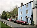
House on Gloucester Street, Wotton-Under-Edge
Branksmere is listed and described at https://historicengland.org.uk/listing/the-list/list-entry/1088921 . This is the B4060.
Image: © Derek Harper
Taken: 27 Oct 2014
0.06 miles
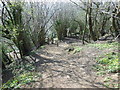
7
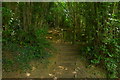
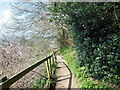
Cotswold Way climbing Wotton Hill
Following footpath CWE/11/2, the Way wastes no time in tackling the Cotswold scarp as it leaves Wotton-Under-Edge heading north. A vertiginous laurel arches across the path.
Image: © Derek Harper
Taken: 2 Jan 2010
0.06 miles
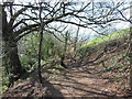
8
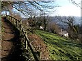
Cotswold Way climbing Wotton Hill (2)
A little further up footpath CWE/11/2 than shown in Image The houses below the steep linear meadow are on Old London Road.
Image: © Derek Harper
Taken: 2 Jan 2010
0.06 miles
9
The Cotswold Way towards Wotton-under-Edge
The Cotswold Way, day four 10:53am
Image: © Ian S
Taken: 20 Apr 2013
0.07 miles
10
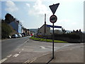
The Cotswold Way on Bradley Road
The Cotswold Way, day four 10:56am
Image: © Ian S
Taken: 20 Apr 2013
0.07 miles