IMAGES TAKEN NEAR TO
Gloucester Street, WOTTON-UNDER-EDGE, GL12 7DN
Introduction
This page details the photographs taken nearby to Gloucester Street, GL12 7DN by members of the Geograph project.
The Geograph project started in 2005 with the aim of publishing, organising and preserving representative images for every square kilometre of Great Britain, Ireland and the Isle of Man.

There are currently over 7.5m images from over14,400 individuals and you can help contribute to the project by visiting https://www.geograph.org.uk
Image Map
Images are licensed for reuse under creativecommons.org/licenses/by-sa/2.0
Notes
- Clicking on the map will re-center to the selected point.
- The higher the marker number, the further away the image location is from the centre of the postcode.
Image Listing (180 Images Found)
Images are licensed for reuse under creativecommons.org/licenses/by-sa/2.0
Image
Details
Distance
1
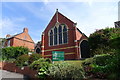
Wotton United Church, Bradley Street, Wotton-under-Edge
Methodist and United Reformed church; founded by an Anglican under sad circumstances http://www.wottonunitedchurch.org.uk/info/history.htm
Image: © Tim Heaton
Taken: 6 Jul 2017
0.04 miles
2
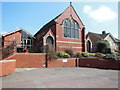
Wotton United Church on Bradley Road
The Cotswold Way, day four 10:58am
Image: © Ian S
Taken: 20 Apr 2013
0.04 miles
3
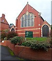
Wotton United Church, Wotton-under-Edge
Viewed across Bradley Street. The name board shows
Wotton United Church
Methodist and United Reformed.
Image: © Jaggery
Taken: 28 Oct 2012
0.04 miles
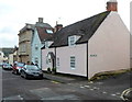
4
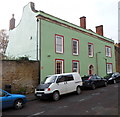
Cotswold House, Wotton-under-Edge
Viewed across Bradley Street. Cotswold House has 17th century origins, later remodelled and extended. Grade II listed in 1952.
Image: © Jaggery
Taken: 28 Oct 2012
0.06 miles
5
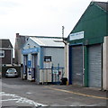
Wotton Tyre & Exhaust Centre, Wotton-under-Edge
Located in Bank Yard, on the south side of Tabernacle Road.
Image: © Jaggery
Taken: 28 Oct 2012
0.07 miles
6
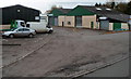
Bank Yard Garage, Wotton-under-Edge
Car servicing and MoT business in Unit 1, Bank Yard Industrial Estate, viewed from Tabernacle Road.
Image: © Jaggery
Taken: 28 Oct 2012
0.07 miles
7
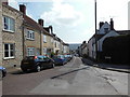
Bradley Street houses, Wotton-under-Edge
The right turn into Westfields is in the foreground.
The blue-grey house in the middle is The Old Dairy House. Behind it is Lyley House. http://www.geograph.org.uk/photo/3716860
Image: © Jaggery
Taken: 28 Oct 2012
0.08 miles
9
Bradley Road at Dryleaze, Wotton-under-Edge
The Cotswold Way, day four 10:56am
Image: © Ian S
Taken: 20 Apr 2013
0.08 miles
10
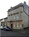
Lyley House, Wotton-under-Edge
Viewed across Bradley Street. Now divided into flats, Lyley House dates
from the mid 18th century, though only the classical facade seen here
is from that period. The main body of the house was rebuilt
after a fire in the late 19th century.
Image: © Jaggery
Taken: 28 Oct 2012
0.08 miles