1
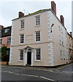
Agriculture House, Wotton-under-Edge
5-storey building at 12 High Street on the corner of Haw Street.
The building under scaffolding next door is a branch of NatWest bank. http://www.geograph.org.uk/photo/3751199
Image: © Jaggery
Taken: 28 Oct 2012
0.00 miles
2
Run out of money
The former Nat West bank in High Street, looking for a new occupier. It went down to part-time opening hours in 2011 before finally closing altogether.
Image: © Neil Owen
Taken: 2 Aug 2014
0.00 miles
3
Haw Street, Wotton-Under-Edge
Image: © Jeff Tomlinson
Taken: 21 Jun 2008
0.01 miles
4
Scaffolding on NatWest in Wotton-under-Edge
Viewed in late October 2012. The bank branch is at 10 High Street.
Image: © Jaggery
Taken: 28 Oct 2012
0.01 miles
5
Wotton British Take-away, Wotton-under-Edge
The fish & chip shop on the right is at 11 High Street. Its neighbours on the left are Norville opticians and Milburys estate and letting agents office.
Image: © Jaggery
Taken: 28 Oct 2012
0.01 miles
6
Fish, chips and mushy peas
Specifically a British takeaway, not just any old takeaway.
Image: © Neil Owen
Taken: 2 Aug 2014
0.01 miles
7
Ordnance Survey Flush Bracket (S1497)
This OS Flush Bracket can be found on the junction on High Street & Haw Street. It marks a point 93.651m above mean sea level.
Image: © Adrian Dust
Taken: 4 Mar 2016
0.01 miles
8
Royal Oak Inn sign, Wotton-under-Edge
Hanging from a bracket on the wall here. http://www.geograph.org.uk/photo/3716697
Image: © Jaggery
Taken: 28 Oct 2012
0.02 miles
9
3-storey house on the corner of Bradley Street and Haw Street, Wotton-under-Edge
Located near the Royal Oak Inn. http://www.geograph.org.uk/photo/3716697
Image: © Jaggery
Taken: 28 Oct 2012
0.02 miles
10
The Cotswold Way on High Street
The Cotswold Way, day four 11:00am
Image: © Ian S
Taken: 20 Apr 2013
0.02 miles


