IMAGES TAKEN NEAR TO
Dryleaze Court, WOTTON-UNDER-EDGE, GL12 7BL
Introduction
This page details the photographs taken nearby to Dryleaze Court, GL12 7BL by members of the Geograph project.
The Geograph project started in 2005 with the aim of publishing, organising and preserving representative images for every square kilometre of Great Britain, Ireland and the Isle of Man.

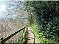
There are currently over 7.5m images from over14,400 individuals and you can help contribute to the project by visiting https://www.geograph.org.uk
Image Map
Images are licensed for reuse under creativecommons.org/licenses/by-sa/2.0
Notes
- Clicking on the map will re-center to the selected point.
- The higher the marker number, the further away the image location is from the centre of the postcode.
Image Listing (82 Images Found)
Images are licensed for reuse under creativecommons.org/licenses/by-sa/2.0
Image
Details
Distance
1
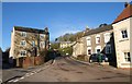
Bradley Street, Wotton-Under-Edge
The street passes Ellerncroft Road (left) and steepens as it climbs to meet Gloucester Street on the slopes of Wotton Hill. No 55 on the right, with its distinctive stepped voussoirs, is listed http://www.imagesofengland.org.uk/Details/Default.aspx?id=128055&mode=adv .
Image: © Derek Harper
Taken: 2 Jan 2010
0.02 miles
2
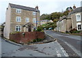
Junction of Bradley Street and Ellerncroft Road, Wotton-under-Edge
Bradley Street on the right climbs towards Wotton Hill past the left turn for Ellerncroft Road. Mealrigg House is between the two roads. The sign arms on the lamppost both show COTSWOLD WAY.
Image: © Jaggery
Taken: 28 Oct 2012
0.07 miles
3
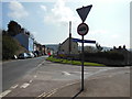
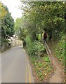
Bradley Road at Dryleaze, Wotton-under-Edge
The Cotswold Way, day four 10:56am
Image: © Ian S
Taken: 20 Apr 2013
0.08 miles
4
The Cotswold Way on Bradley Road
The Cotswold Way, day four 10:56am
Image: © Ian S
Taken: 20 Apr 2013
0.08 miles
5
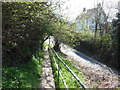
Cotswold Way leaving Wotton-Under-Edge
A reverse view of Image, with the Way following footpath CWE 11/2 up a very steep hillside. The B4060 Bradley Road continues on the left.
Image: © Derek Harper
Taken: 27 Oct 2014
0.10 miles
6
House on Gloucester Street, Wotton-Under-Edge
Branksmere is listed and described at https://historicengland.org.uk/listing/the-list/list-entry/1088921 . This is the B4060.
Image: © Derek Harper
Taken: 27 Oct 2014
0.10 miles
7
The Cotswold Way at Bradley Road
The Cotswold Way, day four 10:54am
Image: © Ian S
Taken: 20 Apr 2013
0.11 miles
8
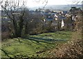
Wotton-Under-Edge from the Cotswold Way
Looking towards the western side of the town from the stretch of the Way shown in Image
Image: © Derek Harper
Taken: 2 Jan 2010
0.12 miles
9
The Cotswold Way towards Wotton-under-Edge
The Cotswold Way, day four 10:53am
Image: © Ian S
Taken: 20 Apr 2013
0.13 miles
10
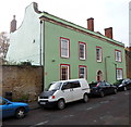
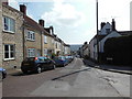
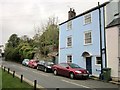
Cotswold House, Wotton-under-Edge
Viewed across Bradley Street. Cotswold House has 17th century origins, later remodelled and extended. Grade II listed in 1952.
Image: © Jaggery
Taken: 28 Oct 2012
0.14 miles