IMAGES TAKEN NEAR TO
Haw Street, WOTTON-UNDER-EDGE, GL12 7AQ
Introduction
This page details the photographs taken nearby to Haw Street, GL12 7AQ by members of the Geograph project.
The Geograph project started in 2005 with the aim of publishing, organising and preserving representative images for every square kilometre of Great Britain, Ireland and the Isle of Man.

There are currently over 7.5m images from over14,400 individuals and you can help contribute to the project by visiting https://www.geograph.org.uk
Image Map
Images are licensed for reuse under creativecommons.org/licenses/by-sa/2.0
Notes
- Clicking on the map will re-center to the selected point.
- The higher the marker number, the further away the image location is from the centre of the postcode.
Image Listing (245 Images Found)
Images are licensed for reuse under creativecommons.org/licenses/by-sa/2.0
Image
Details
Distance
1
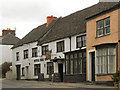
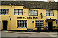
Royal Oak Inn
The Royal Oak Inn on Haw Street is a seventeenth century inn with a mainly 19th century facade. It is a Grade II* listed building ( http://www.britishlistedbuildings.co.uk/en-128122-royal-oak-3-wotton-under-edge British Listed Buildings)
Image: © David Dixon
Taken: 29 Feb 2012
0.02 miles
2
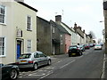
Haw Street, Wotton-under-Edge
The B4058 towards Wickwar.
Note the old-style bookmaker's premises to the left.
Image: © Jonathan Billinger
Taken: 21 Jan 2010
0.02 miles
3
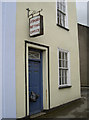
Bagging a winner
Wotton-under-Edge has a less than salubrious licensed office.
Image: © Neil Owen
Taken: 2 Aug 2014
0.02 miles
4
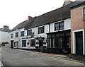
Royal Oak Inn, Wotton-under-Edge
Viewed across Haw Street from the corner of High Street.
http://www.geograph.org.uk/photo/3716716 to a view of the inn sign.
Image: © Jaggery
Taken: 28 Oct 2012
0.03 miles
5
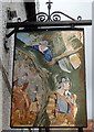
Royal Oak Inn sign, Wotton-under-Edge
Hanging from a bracket on the wall here. http://www.geograph.org.uk/photo/3716697
Image: © Jaggery
Taken: 28 Oct 2012
0.04 miles
6
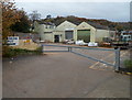
Wotton Building Supplies, Wotton-under-Edge
The yard is on the west side of Well House. http://www.geograph.org.uk/photo/3748543
Image: © Jaggery
Taken: 28 Oct 2012
0.04 miles
8

Ordnance Survey Flush Bracket (S1497)
This OS Flush Bracket can be found on the junction on High Street & Haw Street. It marks a point 93.651m above mean sea level.
Image: © Adrian Dust
Taken: 4 Mar 2016
0.05 miles
9
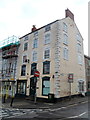
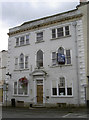
Agriculture House, Wotton-under-Edge
5-storey building at 12 High Street on the corner of Haw Street.
The building under scaffolding next door is a branch of NatWest bank. http://www.geograph.org.uk/photo/3751199
Image: © Jaggery
Taken: 28 Oct 2012
0.05 miles
10
Run out of money
The former Nat West bank in High Street, looking for a new occupier. It went down to part-time opening hours in 2011 before finally closing altogether.
Image: © Neil Owen
Taken: 2 Aug 2014
0.05 miles