IMAGES TAKEN NEAR TO
Dryleaze, WOTTON-UNDER-EDGE, GL12 7AL
Introduction
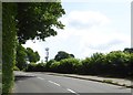
This page details the photographs taken nearby to Dryleaze, GL12 7AL by members of the Geograph project.
The Geograph project started in 2005 with the aim of publishing, organising and preserving representative images for every square kilometre of Great Britain, Ireland and the Isle of Man.

There are currently over 7.5m images from over14,400 individuals and you can help contribute to the project by visiting https://www.geograph.org.uk
Image Map
Images are licensed for reuse under creativecommons.org/licenses/by-sa/2.0
Notes
- Clicking on the map will re-center to the selected point.
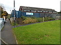
- The higher the marker number, the further away the image location is from the centre of the postcode.
Image Listing (149 Images Found)
Images are licensed for reuse under creativecommons.org/licenses/by-sa/2.0
Image
Details
Distance
1
The Chipping Surgery, Wotton-under-Edge
The medical surgery is at the western end of Symn Lane, near the fire station. http://www.geograph.org.uk/photo/3728560
Image: © Jaggery
Taken: 28 Oct 2012
0.10 miles
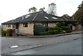
2
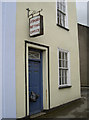
Bagging a winner
Wotton-under-Edge has a less than salubrious licensed office.
Image: © Neil Owen
Taken: 2 Aug 2014
0.11 miles
3
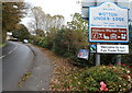
Western boundary of Wotton-under-Edge
The B4058 reaches Wotton-under-Edge, a market town in the Stroud district of Gloucestershire.
Image: © Jaggery
Taken: 28 Oct 2012
0.11 miles
4
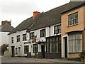
Royal Oak Inn
The Royal Oak Inn on Haw Street is a seventeenth century inn with a mainly 19th century facade. It is a Grade II* listed building ( http://www.britishlistedbuildings.co.uk/en-128122-royal-oak-3-wotton-under-edge British Listed Buildings)
Image: © David Dixon
Taken: 29 Feb 2012
0.12 miles
5
Wotton-under-Edge allotments
Viewed from New Road, this is one of two sites in the town managed by Wotton-under-Edge Town Council's Allotments Committee.
Image: © Jaggery
Taken: 28 Oct 2012
0.12 miles
6
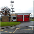
Wotton-under-Edge Community Fire and Rescue Station
Viewed across Symn Lane, part of the Gloucestershire Fire & Rescue Service.
Image: © Jaggery
Taken: 28 Oct 2012
0.13 miles
7
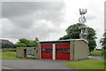
Wotton-Under-Edge Fire Station
Wotton-Under-Edge Fire Station, Symn Lane, Wotton-Under-Edge, is station R09 of the Gloucestershire Fire & Rescue Service.
Image: © Kevin Hale
Taken: 28 May 2006
0.13 miles
8
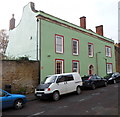
Cotswold House, Wotton-under-Edge
Viewed across Bradley Street. Cotswold House has 17th century origins, later remodelled and extended. Grade II listed in 1952.
Image: © Jaggery
Taken: 28 Oct 2012
0.13 miles
9
Communications mast, Wotton-Under-Edge
Seen from New Road on the edge of the village
Image: © David Smith
Taken: 15 Jun 2018
0.13 miles
10
Wotton Pool, Wotton-under-Edge
The swimming pool building is next door to the fire station. http://www.geograph.org.uk/photo/3728560
Image: © Jaggery
Taken: 28 Oct 2012
0.14 miles