IMAGES TAKEN NEAR TO
Rope Walk, WOTTON-UNDER-EDGE, GL12 7AA
Introduction
This page details the photographs taken nearby to Rope Walk, GL12 7AA by members of the Geograph project.
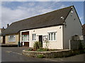
The Geograph project started in 2005 with the aim of publishing, organising and preserving representative images for every square kilometre of Great Britain, Ireland and the Isle of Man.

There are currently over 7.5m images from over14,400 individuals and you can help contribute to the project by visiting https://www.geograph.org.uk
Image Map
Images are licensed for reuse under creativecommons.org/licenses/by-sa/2.0
Notes
- Clicking on the map will re-center to the selected point.
- The higher the marker number, the further away the image location is from the centre of the postcode.
Image Listing (271 Images Found)
Images are licensed for reuse under creativecommons.org/licenses/by-sa/2.0
Image
Details
Distance
1
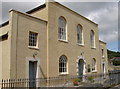
Baptist church
Wotton's Baptist Church, as seen from Rope Walk.
Image: © Neil Owen
Taken: 2 Aug 2014
0.01 miles
2
Wotton Baptist Church, Wotton-under-Edge
Located in Rope Walk. The church describes itself as a "lively Evangelical Charismatic Baptist church".
Image: © Jaggery
Taken: 28 Oct 2012
0.01 miles
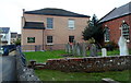
3
Baptist graveyard
Right next to the church and an associated building at the rear of the Town Hall.
Image: © Neil Owen
Taken: 2 Aug 2014
0.02 miles
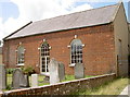
4
The Chipping Club Room, Wotton-under-Edge
A small board near the door shows that the Society of Friends (Quakers)
are meeting here for worship today at 10.30am. All are welcome.
Image: © Jaggery
Taken: 28 Oct 2012
0.02 miles
5
The Chipping Club Room
Meeting room for religious and charitable groups.
Image: © Neil Owen
Taken: 2 Aug 2014
0.02 miles
6
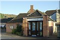
Wotton heritage centre with church in the distance
Image: © Jeff Tomlinson
Taken: 22 Jun 2008
0.02 miles
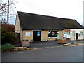
7
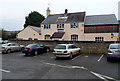
Youth Centre in Wotton-under-Edge
Viewed from The Chipping Car Park, the Youth Centre occupies a converted former police station.
Image: © Jaggery
Taken: 28 Oct 2012
0.02 miles
8
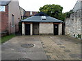
Rope Walk public toilets, Wotton-under-Edge
Set back from the west side of Rope Walk, a lane on the south side of Long Street.
Image: © Jaggery
Taken: 28 Oct 2012
0.02 miles
9
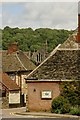
Wotton-Under-Edge old fire station
Wotton-Under-Edge old fire station, The Chipping, Wotton-Under-Edge, Gloucestershire, now used as the town's Heritage Centre
Image: © Kevin Hale
Taken: 29 Oct 2007
0.03 miles
10
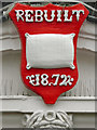
Town Hall (detail)
The ornamental red plaque above the door to Image] gives the date of its alteration.
Image: © David Dixon
Taken: 29 Feb 2012
0.03 miles