IMAGES TAKEN NEAR TO
Southgate Street, GLOUCESTER, GL1 1XQ
Introduction
This page details the photographs taken nearby to Southgate Street, GL1 1XQ by members of the Geograph project.
The Geograph project started in 2005 with the aim of publishing, organising and preserving representative images for every square kilometre of Great Britain, Ireland and the Isle of Man.

There are currently over 7.5m images from over14,400 individuals and you can help contribute to the project by visiting https://www.geograph.org.uk
Image Map
Images are licensed for reuse under creativecommons.org/licenses/by-sa/2.0
Notes
- Clicking on the map will re-center to the selected point.
- The higher the marker number, the further away the image location is from the centre of the postcode.
Image Listing (820 Images Found)
Images are licensed for reuse under creativecommons.org/licenses/by-sa/2.0
Image
Details
Distance
1
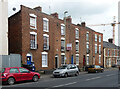
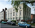
143-151 Southgate Street, Gloucester
Built c1830. Quite mean, the central three houses having only a single window to each floor. Grade II listed.
Image: © Stephen Richards
Taken: 17 May 2015
0.02 miles
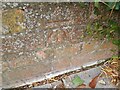
2
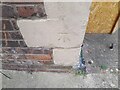
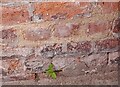
Ordnance Survey Cut Mark
This OS cut mark can be found on No153 Southgate Street. It marks a point 13.945m above mean sea level.
Image: © Adrian Dust
Taken: 9 Jul 2022
0.04 miles
3
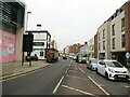
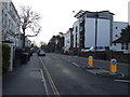
A4301 Bristol Road Gloucester looking northwards
Image: © Roy Hughes
Taken: 16 Dec 2021
0.04 miles
4
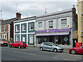
155-157 Southgate Street, Gloucester
Built c1835-40 so on the cusp between Georgian and Victorian eras. Grade II listed.
No. 157 was a Chinese restaurant, Blossom.
Image: © Stephen Richards
Taken: 17 May 2015
0.05 miles
5
13-15 Spa Road, Gloucester
Built as the Spa Hotel in 1818 by the spa company which developed the area. It was enlarged in 1851 by Jacques & Son. Lots of incised decoration. Grade II listed.
Now flats.
Image: © Stephen Richards
Taken: 17 May 2015
0.05 miles
7
Ordnance Survey Cut Mark
This very damaged OS cut mark can be found on No1 Llanthony Road. It marks a point 14.88m above mean sea level.
Image: © Adrian Dust
Taken: 9 Jul 2022
0.06 miles
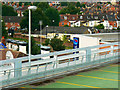
8
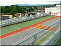
Gloucester Quays car park, High Orchard Street, Gloucester
I've been wandering around on the car park roof for quite a while and, apart from a lot of seagulls, the place is devoid of activity. The viewpoint is level 4 and the empty parking slots are on level 3.
Image: © Brian Robert Marshall
Taken: 6 Aug 2010
0.06 miles
9
Gloucester Quays car park, High Orchard Street, Gloucester
Same viewpoint as for this one http://www.geograph.org.uk/photo/1999390 but with some zoom applied. There is a Travelodge hotel just beyond the car park http://www.travelodge.co.uk/search_and_book/hotel_overview.php?hotel_id=395 The terraced houses beyond that are in Weston Road.
Image: © Brian Robert Marshall
Taken: 6 Aug 2010
0.06 miles
10
Ordnance Survey Cut Mark
This OS cut mark can be found on the wall of Cedar House, Spa Road. It marks a point 15.307m above mean sea level.
Image: © Adrian Dust
Taken: 9 Jul 2022
0.06 miles