IMAGES TAKEN NEAR TO
Spa Road, GLOUCESTER, GL1 1UZ
Introduction
This page details the photographs taken nearby to Spa Road, GL1 1UZ by members of the Geograph project.
The Geograph project started in 2005 with the aim of publishing, organising and preserving representative images for every square kilometre of Great Britain, Ireland and the Isle of Man.

There are currently over 7.5m images from over14,400 individuals and you can help contribute to the project by visiting https://www.geograph.org.uk
Image Map
Images are licensed for reuse under creativecommons.org/licenses/by-sa/2.0
Notes
- Clicking on the map will re-center to the selected point.
- The higher the marker number, the further away the image location is from the centre of the postcode.
Image Listing (578 Images Found)
Images are licensed for reuse under creativecommons.org/licenses/by-sa/2.0
Image
Details
Distance
1
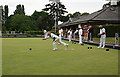
Bowling Match in Gloucester Park
Sportsmen from a wide area were competing in this match.
Image: © Anne Burgess
Taken: 7 Jul 2014
0.01 miles
2
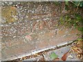
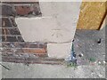
Ordnance Survey Cut Mark
This OS cut mark can be found on the wall of Cedar House, Spa Road. It marks a point 15.307m above mean sea level.
Image: © Adrian Dust
Taken: 9 Jul 2022
0.03 miles
3
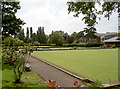
Spa Road greens
Home of the Gloucester Spa Bowling & Social Club. The greens date back to before the Second World War, and are beside what used to be the old spa and pump rooms.
Image: © Neil Owen
Taken: 19 Jun 2013
0.03 miles
4
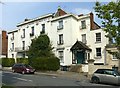
Sherbourne House, Spa Road, Gloucester
Despite the name, this was built as 3 separate houses, the centre 3 bays forming one and the flanking wings forming the other two. Built c1825, Listed Grade II*. The rather incongruous timbered porch is interesting in its own right as it incorporates a number of pieces of medieval timberwork, including the carved bargeboards, put together in the late 19th century.
Image: © Alan Murray-Rust
Taken: 15 Apr 2019
0.04 miles
5
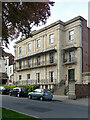
29-31 Spa Road, Gloucester
Anything Cheltenham can do ... Originally Somerset House, built c1825 by Robert Smirke for John Phillpotts. Good ironwork (Image]). Grade II* listed.
Formerly the Judge's Lodgings, when it was converted for the Assize Court in 1864, now flats.
Image: © Stephen Richards
Taken: 17 May 2015
0.04 miles
6
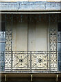
Detail of 29-31 Spa Road, Gloucester
Part of the delicate wrought-iron verandah.
Wider view: Image
Image: © Stephen Richards
Taken: 17 May 2015
0.04 miles
7
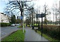
Spa Road meets Montpellier by Gloucester Park
Bend represents junction of roads and path into park, well signed here.
Image: © Clint Mann
Taken: 31 Dec 2014
0.06 miles
8
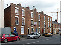
143-151 Southgate Street, Gloucester
Built c1830. Quite mean, the central three houses having only a single window to each floor. Grade II listed.
Image: © Stephen Richards
Taken: 17 May 2015
0.06 miles
9
Ordnance Survey Cut Mark
This OS cut mark can be found on No153 Southgate Street. It marks a point 13.945m above mean sea level.
Image: © Adrian Dust
Taken: 9 Jul 2022
0.06 miles
10
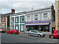
155-157 Southgate Street, Gloucester
Built c1835-40 so on the cusp between Georgian and Victorian eras. Grade II listed.
No. 157 was a Chinese restaurant, Blossom.
Image: © Stephen Richards
Taken: 17 May 2015
0.07 miles