IMAGES TAKEN NEAR TO
Norfolk Street, GLOUCESTER, GL1 1US
Introduction
This page details the photographs taken nearby to Norfolk Street, GL1 1US by members of the Geograph project.
The Geograph project started in 2005 with the aim of publishing, organising and preserving representative images for every square kilometre of Great Britain, Ireland and the Isle of Man.

There are currently over 7.5m images from over14,400 individuals and you can help contribute to the project by visiting https://www.geograph.org.uk
Image Map
Images are licensed for reuse under creativecommons.org/licenses/by-sa/2.0
Notes
- Clicking on the map will re-center to the selected point.
- The higher the marker number, the further away the image location is from the centre of the postcode.
Image Listing (996 Images Found)
Images are licensed for reuse under creativecommons.org/licenses/by-sa/2.0
Image
Details
Distance
1
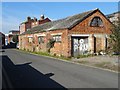
Old industrial building
What appears to be a disused old industrial building on Albion Street at the back of Brunswick Square.
Image: © Philip Halling
Taken: 23 Feb 2019
0.03 miles
2
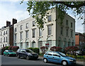
13-15 Spa Road, Gloucester
Built as the Spa Hotel in 1818 by the spa company which developed the area. It was enlarged in 1851 by Jacques & Son. Lots of incised decoration. Grade II listed.
Now flats.
Image: © Stephen Richards
Taken: 17 May 2015
0.03 miles
3
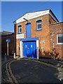
TS Gloucester
TS Gloucester Sea Cadets Corps on Albion Street in Gloucester. The building has the appearance of an old warehouse with a hoist above the door and below the apex of the gable.
Image: © Philip Halling
Taken: 23 Feb 2019
0.04 miles
4
Gloucester - houses on south side of Brunswick Square
Image: © Dave Bevis
Taken: 11 Jan 2014
0.05 miles
5
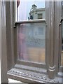
Etched glass window - Whitesmiths Arms
One of the endearing features of pub architecture are etched glass windows. In this window, you can see a reflection of The Tall Ship pub!
Image: © Helen Iwanczuk
Taken: 26 May 2011
0.05 miles
6
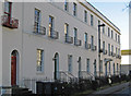
Regency houses in Brunswick Square
This houses are Regency and were built in the 1820s, they are Grade II listed.
Image: © Philip Halling
Taken: 23 Feb 2019
0.05 miles
9
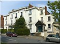
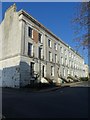
Sherbourne House, Spa Road, Gloucester
Despite the name, this was built as 3 separate houses, the centre 3 bays forming one and the flanking wings forming the other two. Built c1825, Listed Grade II*. The rather incongruous timbered porch is interesting in its own right as it incorporates a number of pieces of medieval timberwork, including the carved bargeboards, put together in the late 19th century.
Image: © Alan Murray-Rust
Taken: 15 Apr 2019
0.06 miles
10
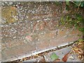
Ordnance Survey Cut Mark
This OS cut mark can be found on the wall of Cedar House, Spa Road. It marks a point 15.307m above mean sea level.
Image: © Adrian Dust
Taken: 9 Jul 2022
0.06 miles