IMAGES TAKEN NEAR TO
The Oxebode, GLOUCESTER, GL1 1RZ
Introduction
This page details the photographs taken nearby to The Oxebode, GL1 1RZ by members of the Geograph project.
The Geograph project started in 2005 with the aim of publishing, organising and preserving representative images for every square kilometre of Great Britain, Ireland and the Isle of Man.

There are currently over 7.5m images from over14,400 individuals and you can help contribute to the project by visiting https://www.geograph.org.uk
Image Map
Images are licensed for reuse under creativecommons.org/licenses/by-sa/2.0
Notes
- Clicking on the map will re-center to the selected point.
- The higher the marker number, the further away the image location is from the centre of the postcode.
Image Listing (1796 Images Found)
Images are licensed for reuse under creativecommons.org/licenses/by-sa/2.0
Image
Details
Distance
1
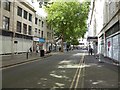
The Oxebode in Gloucester
A large Debenhams store is on the right and Northgate Street is at the end of the road.
Image: © Philip Halling
Taken: 9 Sep 2017
0.01 miles
2
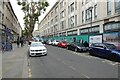
The Oxbode, Gloucester
The building on the right was formerly the city's Debenham's store; it is currently undergoing redevelopment and will become a university campus.
Image: © Philip Halling
Taken: 30 Sep 2023
0.01 miles
3
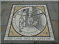
Gloucester - The Lane Was So Narrow
Mosaic in The Oxebode depicting an old Gloucester tale. Have a butchers!
www.visitgloucester.co.uk
Image: © Colin Smith
Taken: 31 Jul 2019
0.01 miles
4
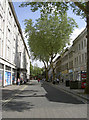
No bull here
Oxbode Street, minus any signs of an open-air butchery. The local tale is recounted in a nursery rhyme when the lane was a great deal narrower and perhaps known as Mitre Street. It's said a large ox was brought to market but became inextricably stuck between the houses. Faced with the problem and no way of moving the poor animal, a butcher was summoned to dispatch and dismember it on the spot.
By the early twentieth century the area was a slum and was cleared and widened to allow a better passage to all. The name Oxbode (ox body) remains.
Image: © Neil Owen
Taken: 19 Jun 2013
0.02 miles
5
New Inn, Northgate Street
Originally built c.1457. In 1973 this was a Berni Inn.
Image: © Alan Longbottom
Taken: Unknown
0.02 miles
6
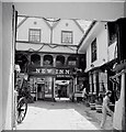
New Inn, Northgate Street
View looking into the courtyard
Image: © Alan Longbottom
Taken: Unknown
0.02 miles
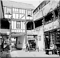
7

New Inn, Gloucester
The New Inn isn't all that new, having been built in 1450 to accommodate visitors to the Benedictine Abbey of St Peter (now Gloucester Cathedral http://www.geograph.org.uk/photo/6091523 ). The arrangement around a courtyard surrounded by first-floor galleries is typical of mediaeval inns, although few have survived to the present day as intact as New Inn. The view takes in the whole courtyard with the passageway towards the front on Northgate Street.
Image: © Rudi Winter
Taken: 16 Mar 2019
0.02 miles
8
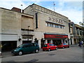
The Regal pub, Gloucester
Wetherspoons pub in Aldate Street in the city centre.
Originally the Regal cinema. Construction began in 1939, but was not completed until 1956 because of the Second World War and postwar building restrictions. Renamed the ABC in 1963, and Cannon in 1988. The cinema closed down in 1990.
Image: © Jaggery
Taken: 13 Apr 2012
0.02 miles
9
Aldate Street locksmiths, Gloucester
Universal Security Group locksmiths at 23 Aldate Street in the city centre.
Image: © Jaggery
Taken: 13 Apr 2012
0.02 miles
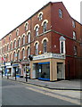
10
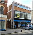
The Co-operative Bank, central Gloucester
Bank branch at 23A St. Aldate Street. Universal Security Group locksmiths http://www.geograph.org.uk/photo/2902490 is on the left.
Image: © Jaggery
Taken: 13 Apr 2012
0.02 miles