IMAGES TAKEN NEAR TO
Eastgate Street, GLOUCESTER, GL1 1QU
Introduction
This page details the photographs taken nearby to Eastgate Street, GL1 1QU by members of the Geograph project.
The Geograph project started in 2005 with the aim of publishing, organising and preserving representative images for every square kilometre of Great Britain, Ireland and the Isle of Man.

There are currently over 7.5m images from over14,400 individuals and you can help contribute to the project by visiting https://www.geograph.org.uk
Image Map
Images are licensed for reuse under creativecommons.org/licenses/by-sa/2.0
Notes
- Clicking on the map will re-center to the selected point.
- The higher the marker number, the further away the image location is from the centre of the postcode.
Image Listing (386 Images Found)
Images are licensed for reuse under creativecommons.org/licenses/by-sa/2.0
Image
Details
Distance
1

Zam Zam in Gloucester
Zam Zam Pizza & Fried Chicken takeaway on the left is at 144 Eastgate Street,
near the A430 junction. Also in view are C&G Nail Bar and Fortune House takeaway.
Image: © Jaggery
Taken: 29 Nov 2014
0.00 miles
3

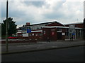
Entrance to GL1 (Gloucester Leisure Centre)
Viewed across Bruton Way. GL1 has a wide range of leisure and sporting facilities, including four swimming pools.
Image: © Jaggery
Taken: 13 Apr 2012
0.02 miles
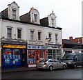
4
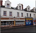
Allsports in Gloucester
Despite its name, Allsports at 126-128 Eastgate Street does not sell footballs, cricket bats or croquet mallets. Its interpretation of sports is the older one of the recreation of hunting, shooting, or fishing. Text on a window shows HUGE DISCOUNTS ON RODS & REELS. The shop's main business is the buying and selling of air weapons, modern or antique.
Asian European Store http://www.geograph.org.uk/photo/4266650 is on the right.
Image: © Jaggery
Taken: 29 Nov 2014
0.02 miles
5
Liquid in Gloucester
Nightclub at 141 Eastgate Street.
Image: © Jaggery
Taken: 29 Nov 2014
0.03 miles
6
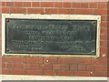
Plaque on the former public baths
See http://www.geograph.org.uk/photo/6130792 for location.
Image: © Alan Murray-Rust
Taken: 15 Apr 2019
0.03 miles
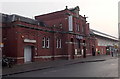
7
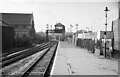
Barton Street Junction Signal Box, Gloucester
A very restricted area resulted in this very distinctive Midland Railway signal box mounted on a massive gantry spanning the tracks. Immediately beyond it is Barton Street level crossing, & beyond that the junction for the High Orchard branch (to the docks). On the left is what was then All Saints Church, a significant building, see: Image
I am standing on Eastgate Station & the approaching train is a single-car DMU that will take the direct line to Stratford-upon-Avon (part of which is now the Gloucestershire & Warwickshire Railway), a service that will cease within a few months with the closure of the line across the Cotswolds to passenger traffic.
Eastgate Station closed in December 1975 - a victim of the road lobby that wanted level crossing in the city to be removed. All trains between the Midlands & Bristol now either have to reverse at Central Station or not stop at Gloucester. The site is now an Asda supermarket.
Image: © Martin Tester
Taken: Unknown
0.03 miles
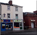
8
Asian European Store in Gloucester
POLISH CZECH TURKISH is on the nameboard of the store on the left at 124 Eastgate Street.
Image: © Jaggery
Taken: 29 Nov 2014
0.03 miles
9
Kebab Delights and Go Peri in Gloucester
Viewed across Eastgate Street. Kebabs, pizzas and burgers on the left,
Afro-Portuguese restaurant and takeaway on the right.
Image: © Jaggery
Taken: 29 Nov 2014
0.03 miles
10
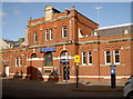
Liquid, but different types
This nightclub occupies what were the public baths before the leisure centre arrived. The baths date from 1891.
Image: © Neil Owen
Taken: 17 Feb 2015
0.03 miles