IMAGES TAKEN NEAR TO
Whitfield Street, GLOUCESTER, GL1 1NB
Introduction
This page details the photographs taken nearby to Whitfield Street, GL1 1NB by members of the Geograph project.
The Geograph project started in 2005 with the aim of publishing, organising and preserving representative images for every square kilometre of Great Britain, Ireland and the Isle of Man.

There are currently over 7.5m images from over14,400 individuals and you can help contribute to the project by visiting https://www.geograph.org.uk
Image Map
Images are licensed for reuse under creativecommons.org/licenses/by-sa/2.0
Notes
- Clicking on the map will re-center to the selected point.
- The higher the marker number, the further away the image location is from the centre of the postcode.
Image Listing (902 Images Found)
Images are licensed for reuse under creativecommons.org/licenses/by-sa/2.0
Image
Details
Distance
1
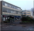
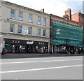
Quality Solicitors Rowbis in Gloucester
This is the Whitfield Street side of Morroway House on the corner of Station Road.
Quality Solicitors Rowbis on the left side of the entrance, Assured Mobility on the right.
Image: © Jaggery
Taken: 29 Nov 2014
0.01 miles
2
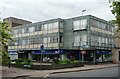
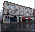
Morroway House, Station Road, Gloucester
Nice and crisp and unspoiled. Clad in green slate. By B.S. Tait, c1961.
Occupied at street level by Rowbis Solicitors and Assured Mobility.
Image: © Stephen Richards
Taken: 17 May 2015
0.02 miles
3
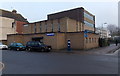
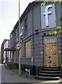
Ebenezer Gospel Hall, Gloucester
On the corner of Russell Street and Whitfield Street, Ebenezer Gospel Hall was built in 1971.
Image: © Jaggery
Taken: 29 Nov 2014
0.02 miles
4
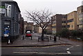
Whitfield Street, Gloucester
Looking SW from the corner of Station Road. The former Fusion http://www.geograph.org.uk/photo/4268255 is on the left.
Image: © Jaggery
Taken: 29 Nov 2014
0.02 miles
5
Former Fusion club to let in Gloucester
To Let boards are on the wall of 1 Station Road on the corner of Whitfield Street in late November 2014. Various reports in 2013 that the former Fusion club building could be converted to a fitness centre & spa, or reopen as a bar, appear to have come to nothing.
Image: © Jaggery
Taken: 29 Nov 2014
0.03 miles
6
Kaspa's Desserts, Lister House, Station Road, Gloucester
Their website states that "Kaspa's are a chain of exciting new dessert houses that offer the world's favourite hot and cold desserts under one roof".
A dental clinic is on the top floor. The To Let board refers to the middle floor.
Image: © Jaggery
Taken: 27 Apr 2016
0.03 miles
7
It's not just the pubs that shut
Fusion in Station Road seems to have befallen the same fate as many a pub - boarded up and now with a Banksy-esque stencil on it. It was extensively refurbished in 2011 but has not survived the down-turn.
See Image] for more scenes of disuse.
Image: © Neil Owen
Taken: 19 Jun 2013
0.03 miles
8
Lister House, Gloucester
The second floor of the Station Road building houses Genix Healthcare Ltd, providers of NHS dentistry and private dentistry. There are also retail units in Lister House, some of which are to let in late November 2014.
Image: © Jaggery
Taken: 29 Nov 2014
0.03 miles
9
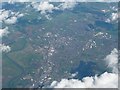
Gloucester from 30,000 feet
On a flight from Luton to Kerry the plane passed over Gloucester. The River Severn is clearly seen to the left. Although this image covers 20 or more squares I have allocated it to the centre of the city. For next aerial image see Image]
Image: © Graham Horn
Taken: 12 Apr 2008
0.03 miles
10
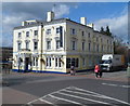
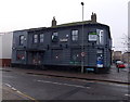
Station Hotel, Gloucester
Built in 1880, the Station Hotel is opposite Gloucester railway station. There are 21 en-suite guest rooms, a restaurant, a café bar and a sports bar.
Image: © Jaggery
Taken: 2 Apr 2012
0.03 miles