IMAGES TAKEN NEAR TO
Park Road, GLOUCESTER, GL1 1LR
Introduction
This page details the photographs taken nearby to Park Road, GL1 1LR by members of the Geograph project.
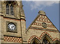
The Geograph project started in 2005 with the aim of publishing, organising and preserving representative images for every square kilometre of Great Britain, Ireland and the Isle of Man.

There are currently over 7.5m images from over14,400 individuals and you can help contribute to the project by visiting https://www.geograph.org.uk
Image Map
Images are licensed for reuse under creativecommons.org/licenses/by-sa/2.0
Notes
- Clicking on the map will re-center to the selected point.
- The higher the marker number, the further away the image location is from the centre of the postcode.
Image Listing (272 Images Found)
Images are licensed for reuse under creativecommons.org/licenses/by-sa/2.0
Image
Details
Distance
1
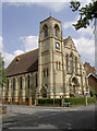
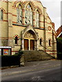
The teachings are different, the place is the same
This striking place of worship seems to have been welcoming different congregations over the years. It is currently a United Reformed Church, but previously it is listed as a Presbyterian and named on older maps as Whitefield Memorial Chapel.
See Image] for more.
Image: © Neil Owen
Taken: 19 Jun 2013
0.02 miles
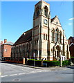
2
St Bartholomew's, Gloucester
Located on the corner of Park Road and Belgrave Road, St Bartholomew's is managed by the Gloucester Charities Trust, an almshouse charity catering for residents of Gloucestershire at the time of application. St Bartholomew's provides sheltered housing for older people. There are 43 1-bedroom flats, a resident management staff and community alarm service.
Image: © Jaggery
Taken: 13 Apr 2012
0.02 miles
3
Grade II listed United Reformed Church, Gloucester
Located on the corner of Park Road and Belgrave Road. The foundation stone of the Whitefield Memorial Presbyterian Church (as it was originally known) was laid on June 6th 1871. Grade II listed in December 1998.
Image: © Jaggery
Taken: 13 Apr 2012
0.02 miles
4
Lifting me up
The church clock tower actually now features a lift - installed in May 1998. See Image] for the foundation stone.
Image: © Neil Owen
Taken: 19 Jun 2013
0.02 miles
5

South side of the United Reformed Church, Gloucester
Viewed across Park Road. The foundation stone of the Whitefield Memorial Presbyterian Church (as it was originally known) was laid on June 6th 1871. Grade II listed in 1998.
Image: © Jaggery
Taken: 6 Nov 2016
0.02 miles
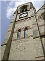
6

Clock tower, United Reformed Church, Gloucester
In the southwest corner of the church on the corner of Park Road and Belgrave Road.
The foundation stone of the Whitefield Memorial Presbyterian
Church (as it was originally known) was laid on June 6th 1871.
The building was Grade II listed in 1998.
Image: © Jaggery
Taken: 6 Nov 2016
0.02 miles
7
Buchanan's gift
The church was opened on 7th May 1872, with James Buchanan presenting the clock. See Image] for more.
Image: © Neil Owen
Taken: 19 Jun 2013
0.03 miles
8
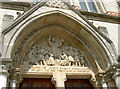
Whitefield's words
George Whitefield (1714-70) was Gloucester's famous preacher whose belief in Methodism helped cause the Great Awakening. His work took him all over Britain and America, where he is still commemorated.
In 1870 the Countess of Huntingdon's flock bought land here, costing some £3,700, to establish a church in his name. It was opened on 7th May 1872 and the stonemason R.J. Boulton of Cheltenham created this bas relief of Whitefield addressing the people; the inscription reads:
"The Love of Jesus Christ Constrains
Me to lift up my Voice like a Trumpet"
See Image] for more.
Image: © Neil Owen
Taken: 19 Jun 2013
0.03 miles
9
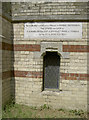
Foundation stone
The Whitefield Memorial Chapel is thought to be on the site of his last sermon to the people in his home city. To mark the centenary of his death the Lord Mayor cut the first sod here on 30th September, 1870 and once work was started this foundation stone was laid by local M.P. Mr S.S. Marling on 6th June, 1871.
The stone contains a number of interesting items, including money, a newspaper and contractual deeds.
See Image] for more.
Image: © Neil Owen
Taken: 19 Jun 2013
0.03 miles
10
Wide steps up to the United Reformed Church, Gloucester
On the Park Road side of the church http://www.geograph.org.uk/photo/5191971 on the corner of Belgrave Road.
Image: © Jaggery
Taken: 6 Nov 2016
0.03 miles