IMAGES TAKEN NEAR TO
St. Michaels Square, GLOUCESTER, GL1 1JB
Introduction
This page details the photographs taken nearby to St. Michaels Square, GL1 1JB by members of the Geograph project.
The Geograph project started in 2005 with the aim of publishing, organising and preserving representative images for every square kilometre of Great Britain, Ireland and the Isle of Man.

There are currently over 7.5m images from over14,400 individuals and you can help contribute to the project by visiting https://www.geograph.org.uk
Image Map
Images are licensed for reuse under creativecommons.org/licenses/by-sa/2.0
Notes
- Clicking on the map will re-center to the selected point.
- The higher the marker number, the further away the image location is from the centre of the postcode.
Image Listing (791 Images Found)
Images are licensed for reuse under creativecommons.org/licenses/by-sa/2.0
Image
Details
Distance
1
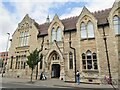
Gloucester - Public Library
Brunswick Road - neo-Gothic Gloucester Public Library, founded 1897.
www.gloucestershire.gov.uk
Image: © Colin Smith
Taken: 31 Jul 2019
0.02 miles
2
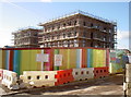
New homes on old graves
The former Gloscat Arts and Media Centre in Brunswick Road is now history. The area has been cleared of the 1960s campus, which allowed a window for modern archeological work to try to discover some new details. As it happens the site yielded an old Roman burial ground - the old town ramparts being just a short distance away to the southeast. Many skeletons were found, mostly simple and humble burials, but each giving a new depth to the understanding. However, the developers are now replacing the classrooms with a large residential opportunity.
Image: © Neil Owen
Taken: 17 Feb 2015
0.02 miles
3
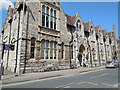
Gloucester Library
In Brunswick Road; details: http://www.gloucestershire.gov.uk/libraries/gloucester
Image: © Paul Gillett
Taken: 7 May 2013
0.02 miles
4
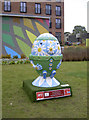
Oops-a-daisy
In celebration of Gloucester being one of the venues for the 2015 Rugby World Cup, these oval gentlemen have appeared around the city. Based partly on the local tale of Humpty Dumpty - actually a siege engine or cannon which was brought to bear on the city walls but which collapsed irreparably - and the handily coincidental shape of a rugby ball, these sculptures form a visitor trail. They have been individually worked on by artists and sponsored by local concerns, and will eventually go to auction for charity.
This 'Scrumpty' is called Oops-a-daisy, by artist Maria Burns and sponsored by Linden Homes - who have redeveloped the former college into modern apartments here.
Image: © Neil Owen
Taken: 22 Sep 2015
0.03 miles
5
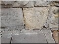
Ordnance Survey Cut Mark
This OS cut mark can be found on the SE face of the College of Art. It marks a point 18.072m above mean sea level.
Image: © Adrian Dust
Taken: 9 Jul 2022
0.03 miles
6
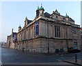
Gloucester City Museum & Art Gallery
Viewed across Brunswick Road. Gloucester City Museum, recently reopened after a Heritage Lottery funded makeover, features new ground floor exhibitions and exhibits giving an interactive experience. Highlights include a Roman kitchen playhouse and medieval street.
Image: © Jaggery
Taken: 29 Nov 2014
0.04 miles
7
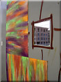
Looking in at looking out
The old college is now long gone and the new housing buildings are close to topping off. The boardings provide a few holes to view the works, and the local students have given plenty of effort in decorating the greyness. The question is: what have the workers painted on the other side of the boardings that the viewers cannot see...
Image: © Neil Owen
Taken: 17 Feb 2015
0.04 miles
8
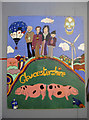
Famous in the county
Some interesting faces and other recognisable residents of the county on boardings where the old college stood.
Image: © Neil Owen
Taken: 17 Feb 2015
0.04 miles
9
Clean it up!
A lamppost has a stern message, but not one heeded by the sprayers.
Image: © Neil Owen
Taken: 17 Feb 2015
0.04 miles
10
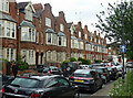
1-13 St Michael's Square, Gloucester
Uncommonly attractive Victorian terrace, dating from the early 1880s.
Image: © Stephen Richards
Taken: 17 May 2015
0.05 miles