IMAGES TAKEN NEAR TO
Taits Hill Road, DURSLEY, GL11 6PR
Introduction
This page details the photographs taken nearby to Taits Hill Road, GL11 6PR by members of the Geograph project.
The Geograph project started in 2005 with the aim of publishing, organising and preserving representative images for every square kilometre of Great Britain, Ireland and the Isle of Man.

There are currently over 7.5m images from over14,400 individuals and you can help contribute to the project by visiting https://www.geograph.org.uk
Image Map (Loading...)


Getting Data...Please wait
Leaflet Map data © OpenStreetMap
Images are licensed for reuse under creativecommons.org/licenses/by-sa/2.0
Notes
- Clicking on the map will re-center to the selected point.
- The higher the marker number, the further away the image location is from the centre of the postcode.
Image Listing (25 Images Found)
Images are licensed for reuse under creativecommons.org/licenses/by-sa/2.0
Image
Details
Distance
1
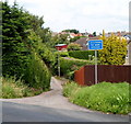
Unsuitable lane for wide vehicles, Cam
Viewed across Tait's Hill Road. What width is too wide for this lane is not shown.
Image: © Jaggery
Taken: 21 Jul 2012
0.07 miles
2
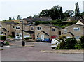
Yew Tree Close, Cam
Viewed from The Quarry, about 80 metres north of Dursley Road.
Image: © Jaggery
Taken: 21 Jul 2012
0.09 miles
3
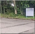
Vale Vats & Referrals nameboard, Stinchcombe
Facing Tait's Hill Road alongside the access road to the vets.
Image: © Jaggery
Taken: 16 Jun 2024
0.09 miles
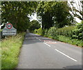
4
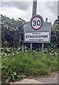
Welcome to STINCHCOMBE - Please drive carefully
Alongside Tait's Hill Road. Stinchcombe is a small village in Gloucestershire.
Image: © Jaggery
Taken: 16 Jun 2024
0.12 miles
5
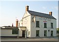
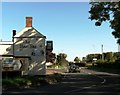
The Yew Tree public house
The Yew tree stands at the junction of the B4066 and B4060 to the northwest of Dursley.
Image: © Sharon Loxton
Taken: 4 Jul 2006
0.12 miles
6
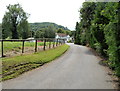
Entrance to Vale Vets, Stinchcombe
The Animal Hospital is set back 80 metres from Tait's Hill Road.
Image: © Jaggery
Taken: 21 Jul 2012
0.13 miles
7
Road signs at a junction near The Yew Tree, Cam
Turn left for Sharpness, Berkeley, Bristol and the M5 southbound.
Turn right for Dursley, Gloucester, M5 northbound and a scenic route.
Image: © Jaggery
Taken: 21 Jul 2012
0.14 miles
8
NE boundary of Stinchcombe
The B4060 from Cam passes the boundary sign for the small village of Stinchcombe, Gloucestershire.
Image: © Jaggery
Taken: 21 Jul 2012
0.14 miles
9
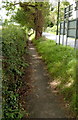
Pavement alongside The Avenue from Cam to Stinchcombe
The B4060 The Avenue passes from Cam on the camera side into
Stinchcombe http://www.geograph.org.uk/photo/3319504 a few metres ahead.
Image: © Jaggery
Taken: 21 Jul 2012
0.14 miles
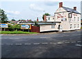
10
The Yew Tree public house, The Quarry, Gloucestershire
Image: © nick macneill
Taken: 14 Oct 2012
0.14 miles