IMAGES TAKEN NEAR TO
Waterley Bottom, DURSLEY, GL11 6EF
Introduction
This page details the photographs taken nearby to Waterley Bottom, GL11 6EF by members of the Geograph project.
The Geograph project started in 2005 with the aim of publishing, organising and preserving representative images for every square kilometre of Great Britain, Ireland and the Isle of Man.

There are currently over 7.5m images from over14,400 individuals and you can help contribute to the project by visiting https://www.geograph.org.uk
Image Map
Images are licensed for reuse under creativecommons.org/licenses/by-sa/2.0
Notes
- Clicking on the map will re-center to the selected point.
- The higher the marker number, the further away the image location is from the centre of the postcode.
Image Listing (21 Images Found)
Images are licensed for reuse under creativecommons.org/licenses/by-sa/2.0
Image
Details
Distance
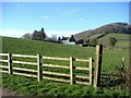
1
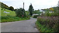
Country crossroads at Waterley Bottom
The fingerpost shows two of the lanes are very steep inclines and you'd best believe it!
Image: © Jonathan Billinger
Taken: 19 Oct 2012
0.09 miles
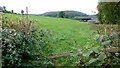
3

Sheep feeding
Sheep feeding in Waterley Bottom.
Image: © Philip Halling
Taken: 18 Jan 2020
0.12 miles
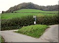
4
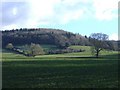
Laycombe Ditch Wood
Seen from Waterley Bottom.
Image: © Roger Cornfoot
Taken: 25 Jan 2007
0.13 miles
5

Farm track to Tedcombe
Farm track to Tedcombe near North Nibley.
Image: © Philip Halling
Taken: 18 Jan 2020
0.14 miles
6
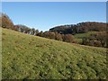
Hillside, Waterley Bottom
From CNN/12/2 as it drops down from Ashen Plains Wood to the lane up Waterley Bottom. Ahead across the valley is Ridings Wood.
Image: © Derek Harper
Taken: 2 Jan 2010
0.14 miles
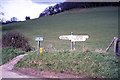
8
Grass triangle near New Inn
Waterley Bottom features several of these; unfortunately, in this part of the world, the road junctions don't usually seem to have names. In the background is Millend Wood on a spur of the scarp.
Image: © Derek Harper
Taken: 27 Oct 2014
0.21 miles
9

Road in Waterley Bottom
Country road passing through Waterley Bottom. The footpath on the left crosses farmland to return to the road near Image], taken 15 years ago.
Image: © Philip Halling
Taken: 18 Jan 2020
0.21 miles
10
View over an old stile
Looking along the line of a footpath from Waterley Bottom towards the wooded Cotswold hills.
Image: © Jonathan Billinger
Taken: 19 Oct 2012
0.22 miles