IMAGES TAKEN NEAR TO
Nibley Green, DURSLEY, GL11 6DH
Introduction
This page details the photographs taken nearby to Nibley Green, GL11 6DH by members of the Geograph project.
The Geograph project started in 2005 with the aim of publishing, organising and preserving representative images for every square kilometre of Great Britain, Ireland and the Isle of Man.

There are currently over 7.5m images from over14,400 individuals and you can help contribute to the project by visiting https://www.geograph.org.uk
Image Map
Images are licensed for reuse under creativecommons.org/licenses/by-sa/2.0
Notes
- Clicking on the map will re-center to the selected point.
- The higher the marker number, the further away the image location is from the centre of the postcode.
Image Listing (11 Images Found)
Images are licensed for reuse under creativecommons.org/licenses/by-sa/2.0
Image
Details
Distance
1
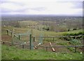
Vegetable patch, North Nibley
With panoramic views across the Severn valley.
Image: © Roger Cornfoot
Taken: 15 Mar 2007
0.08 miles
3
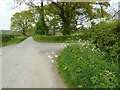
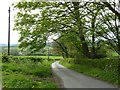
Crossroads near North Nibley
The road on the left is a no through road, going to Bush Street Farm.
Image: © Philip Halling
Taken: 19 Apr 2017
0.22 miles
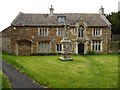
4
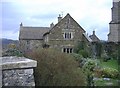
Chantry House, North Nibley
In the shadow of St Martin's Church.
Image: © Roger Cornfoot
Taken: 15 Mar 2007
0.23 miles
5
St Martins Church, North Nibley, Gloucestershire 2015
Image: © Ray Bird
Taken: 18 Sep 2015
0.24 miles
6
The Chantry, Frog Lane, North Nibley, Gloucestershire 2015
Image: © Ray Bird
Taken: 18 Sep 2015
0.24 miles
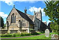
7
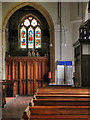
St Martin's Church, West Window
Image], on Frog Lane, dates from the 15th century (tower dated 1632). Altered and restored in the nineteenth century (1836, 1859 and 1873). It is a Grade II* listed building. (http://www.britishlistedbuildings.co.uk/en-394681-church-of-st-martin-north-nibley - British listed buildings)
Image: © David Dixon
Taken: 29 Feb 2012
0.25 miles
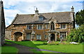
8
The Chantry, North Nibley
The Chantry which overlooks the churchyard of North Nibley church. The building which dates back to the 15th century was formerly a manorial house or priest's house. The building is Grade II listed. https://www.historicengland.org.uk/listing/the-list/list-entry/1290704
Image: © Philip Halling
Taken: 19 Apr 2017
0.25 miles
9
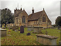
St Martin's Parish Church, North Nibley
St Martin's Parish Church, on Frog Lane, North Nibley, dates from the 15th century (tower dated 1632). Altered and restored in the nineteenth century (1836, 1859 and 1873). It is a Grade II* listed building. (http://www.britishlistedbuildings.co.uk/en-394681-church-of-st-martin-north-nibley - British listed buildings)
Image: © David Dixon
Taken: 29 Feb 2012
0.25 miles
10
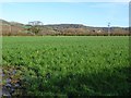
Farmland near Nibley Green
Farmland near Nibley Green with Stinchcombe Hill in the background.
Image: © Philip Halling
Taken: 18 Jan 2020
0.25 miles