IMAGES TAKEN NEAR TO
Upper Wick, DURSLEY, GL11 6DE
Introduction
This page details the photographs taken nearby to GL11 6DE by members of the Geograph project.
The Geograph project started in 2005 with the aim of publishing, organising and preserving representative images for every square kilometre of Great Britain, Ireland and the Isle of Man.

There are currently over 7.5m images from over14,400 individuals and you can help contribute to the project by visiting https://www.geograph.org.uk
Image Map
Images are licensed for reuse under creativecommons.org/licenses/by-sa/2.0
Notes
- Clicking on the map will re-center to the selected point.
- The higher the marker number, the further away the image location is from the centre of the postcode.
Image Listing (4 Images Found)
Images are licensed for reuse under creativecommons.org/licenses/by-sa/2.0
Image
Details
Distance
1
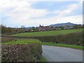
Middle Wick Cottages
Together with Middle Wick Farm, this group of cottages makes up the entire hamlet of Middle Wick.
Image: © Roger May
Taken: 8 Nov 2005
0.09 miles
2
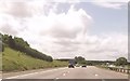
Signs for Michaelwood Services southbound
Image: © John Firth
Taken: 8 Jun 2014
0.10 miles
3
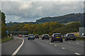
Stroud District : M5 Motorway
The M5 Motorway between Junction 14 (Falfield) and Junction 13 (Stroudwater).
Image: © Lewis Clarke
Taken: 30 Sep 2018
0.13 miles
4
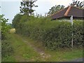
Lower Wick Footpath
Adjacent to Lower Wick Farm is this entry to the footpath leading across the field to join Haycroft Lane a little further west.
Image: © Roger May
Taken: 5 Sep 2005
0.16 miles