IMAGES TAKEN NEAR TO
Wick Road, DURSLEY, GL11 6BD
Introduction
This page details the photographs taken nearby to Wick Road, GL11 6BD by members of the Geograph project.
The Geograph project started in 2005 with the aim of publishing, organising and preserving representative images for every square kilometre of Great Britain, Ireland and the Isle of Man.

There are currently over 7.5m images from over14,400 individuals and you can help contribute to the project by visiting https://www.geograph.org.uk
Image Map (Loading...)


Getting Data...Please wait
Leaflet Map data © OpenStreetMap
Images are licensed for reuse under creativecommons.org/licenses/by-sa/2.0
Notes
- Clicking on the map will re-center to the selected point.
- The higher the marker number, the further away the image location is from the centre of the postcode.
Image Listing (7 Images Found)
Images are licensed for reuse under creativecommons.org/licenses/by-sa/2.0
Image
Details
Distance
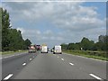
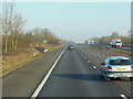
2
Stroud District : The M5 Motorway
The M5 Motorway heading through the Stroud District of Gloucestershire.
Image: © Lewis Clarke
Taken: 29 Oct 2013
0.12 miles
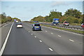
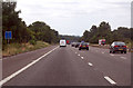
3
Stroud District : M5 Motorway
The M5 Motorway between Junction 14 (Falfield) and Junction 13 (Stroudwater).
Image: © Lewis Clarke
Taken: 30 Sep 2018
0.13 miles

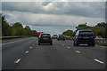
6
M5 near Stinchcombe
At Marker A112.5
Image: © J.Hannan-Briggs
Taken: 30 Jul 2014
0.14 miles