IMAGES TAKEN NEAR TO
Shutehay Drive, DURSLEY, GL11 5UT
Introduction
This page details the photographs taken nearby to Shutehay Drive, GL11 5UT by members of the Geograph project.
The Geograph project started in 2005 with the aim of publishing, organising and preserving representative images for every square kilometre of Great Britain, Ireland and the Isle of Man.

There are currently over 7.5m images from over14,400 individuals and you can help contribute to the project by visiting https://www.geograph.org.uk
Image Map (Loading...)


Getting Data...Please wait
Leaflet Map data © OpenStreetMap
Images are licensed for reuse under creativecommons.org/licenses/by-sa/2.0
Notes
- Clicking on the map will re-center to the selected point.
- The higher the marker number, the further away the image location is from the centre of the postcode.
Image Listing (41 Images Found)
Images are licensed for reuse under creativecommons.org/licenses/by-sa/2.0
Image
Details
Distance
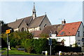
1

St Bartholomew's Church, Lower Cam
Lower Cam Parish Church, built in 1844.
Image: © David Dixon
Taken: 29 Feb 2012
0.05 miles
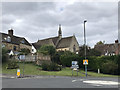
2

Entrance to St Bartholomew's Church, Cam
The Church of England church is located in a rather cramped site. A combination of bright sunshine and restricted views meant that this view, partly obscured by trees, was the best available at the time.
Image: © Jaggery
Taken: 7 Oct 2012
0.05 miles
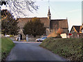
3
Top half of St Bartholomew's Church, Cam
Viewed from the junction of High Street and Chapel Street.
Image: © Jaggery
Taken: 7 Oct 2012
0.05 miles
5
Parish Church of St Bartholomew, Lower Cam
St Bartholomew's Church was built in 1844.
Image: © David Dixon
Taken: 29 Feb 2012
0.06 miles
6

Lower Cam Parish Church
St Bartholomew's Church, built in 1844.
Image: © David Dixon
Taken: 29 Feb 2012
0.06 miles
7
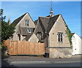
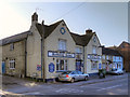
St Bartholomew's Church Hall, Cam
Mid 19th century building in Cam Pitch, to the SE of the church. http://www.geograph.org.uk/photo/3173221
Image: © Jaggery
Taken: 7 Oct 2012
0.07 miles
8
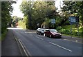
Cam Pitch, Cam
The A4135, here named Cam Pitch, climbs away from High Street and Chapel Street in the centre of Cam. The sign on the right shows 1½ miles to Dursley, 5 miles to Wotton-under-Edge.
Image: © Jaggery
Taken: 7 Oct 2012
0.08 miles
10
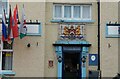
Berkeley Arms (2) - coat of arms, 19 High Street, Lower Cam, Glos
Named after the local Berkeley family, the family coat of arms is above the entrance door. At present there is no conventional sign, but the pub's name is above the ground floor windows.
Image
Image: © P L Chadwick
Taken: 25 Jul 2021
0.09 miles