IMAGES TAKEN NEAR TO
Bowers Lea, DURSLEY, GL11 5PR
Introduction
This page details the photographs taken nearby to Bowers Lea, GL11 5PR by members of the Geograph project.
The Geograph project started in 2005 with the aim of publishing, organising and preserving representative images for every square kilometre of Great Britain, Ireland and the Isle of Man.

There are currently over 7.5m images from over14,400 individuals and you can help contribute to the project by visiting https://www.geograph.org.uk
Image Map
Images are licensed for reuse under creativecommons.org/licenses/by-sa/2.0
Notes
- Clicking on the map will re-center to the selected point.
- The higher the marker number, the further away the image location is from the centre of the postcode.
Image Listing (36 Images Found)
Images are licensed for reuse under creativecommons.org/licenses/by-sa/2.0
Image
Details
Distance
1
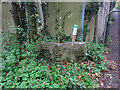
Stone Stile, Elstub Lane
The remains of a slab stile. Cam have numbered their Stone Stiles, this is number 13. It has a companion stone because this is at a cross roads of footpaths (see the long shot Image). This is the Eastern (LH) of the two. For Cam's list of Stone Stiles see https://www.camparishcouncil.gov.uk/uploads/april-2021-stone-stiles-in-cam.pdf .
Image: © Mr Red
Taken: 3 Dec 2021
0.12 miles
2
Two Stone Stiles, Elstub Lane
The remains of a slab stile. Cam have numbered their Stone Stiles, this is probably number 13a, but there is no plaque to indicate. It has a companion stone because this is at a cross roads of footpaths (see the LH stone Image). For Cam's list of Stone Stiles see https://www.camparishcouncil.gov.uk/uploads/april-2021-stone-stiles-in-cam.pdf .
Image: © Mr Red
Taken: 3 Dec 2021
0.12 miles
3
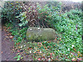
Stone Stile, Elstub Lane
The remains of a slab stile. Cam have numbered their Stone Stiles, it does not have a plaque but is probably number 13a. It has a companion stone (Image) because this is at a cross roads of footpaths (see the long shot Image). This is the Western (RH) of the two. For Cam's list of Stone Stiles see https://www.camparishcouncil.gov.uk/uploads/april-2021-stone-stiles-in-cam.pdf .
Image: © Mr Red
Taken: 3 Dec 2021
0.12 miles
5
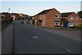
Manor Avenue, Lower Cam
A lady is optimistically mowing grass on this wet Friday in June.
Image: © Jonathan Billinger
Taken: 15 Jun 2012
0.18 miles
6

St Bartholomew's Church, Lower Cam
Lower Cam Parish Church, built in 1844.
Image: © David Dixon
Taken: 29 Feb 2012
0.19 miles
7
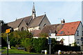
Top half of St Bartholomew's Church, Cam
Viewed from the junction of High Street and Chapel Street.
Image: © Jaggery
Taken: 7 Oct 2012
0.20 miles
8

Entrance to St Bartholomew's Church, Cam
The Church of England church is located in a rather cramped site. A combination of bright sunshine and restricted views meant that this view, partly obscured by trees, was the best available at the time.
Image: © Jaggery
Taken: 7 Oct 2012
0.20 miles
9
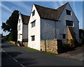
Grade II* listed The Steps, Cam
The large detached house in Woodend Lane was built as a farmhouse in the late
16th and early 17th century. Grade II (star) listed in 1983 as Steps Farmhouse,
later changed to Steps House. At the October 2012 date of this photo, the house
was named The Steps.
Image: © Jaggery
Taken: 7 Oct 2012
0.20 miles
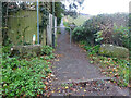
10
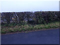
Stone Stile, Draycott
Stile, in the hedge along Woodend Lane, on the line of a de-registered/realigned footpath. The close-up view is Image
Image: © Mr Red
Taken: 9 Dec 2021
0.20 miles