IMAGES TAKEN NEAR TO
High Street, DURSLEY, GL11 5LF
Introduction
This page details the photographs taken nearby to High Street, GL11 5LF by members of the Geograph project.
The Geograph project started in 2005 with the aim of publishing, organising and preserving representative images for every square kilometre of Great Britain, Ireland and the Isle of Man.

There are currently over 7.5m images from over14,400 individuals and you can help contribute to the project by visiting https://www.geograph.org.uk
Image Map
Images are licensed for reuse under creativecommons.org/licenses/by-sa/2.0
Notes
- Clicking on the map will re-center to the selected point.
- The higher the marker number, the further away the image location is from the centre of the postcode.
Image Listing (42 Images Found)
Images are licensed for reuse under creativecommons.org/licenses/by-sa/2.0
Image
Details
Distance
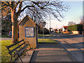
1
Bus shelter at the end of Knapp Lane, Lower Cam
Image: © David Smith
Taken: 15 Jun 2018
0.02 miles
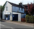
3
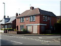
Derelict number 55 High Street, Cam
Probably once a corner shop, 55 High Street, on the corner of Knapp Lane,
is boarded up at the early October 2012 date of this view.
Image: © Jaggery
Taken: 7 Oct 2012
0.03 miles
5
Kayles, Cam
Newsagents and news delivery service at 47 High Street.
Image: © Jaggery
Taken: 7 Oct 2012
0.03 miles
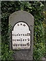
6
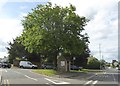
Old Milestone by A4135, High Street, between Nos. 38 & 42
The Milestone is located against large ivy bush on the East of the road. Parish of Cam (Stroud District). Metal plate attached to stone post, Dursley plate design, erected by the Berkley & Dursley (Division) turnpike trust in the 19th Century, beginning delamination on front. An earlier photograph can be found here: https://www.geograph.org.uk/photo/6051140
Inscription reads:-
GLOS'TER / 13 / DURSLEY 2 / WOTTON / 6 : : CAM
Grade II listed. List Entry Number: 1170415 https://historicengland.org.uk/listing/the-list/list-entry/1170415
Milestone Society National ID: GL_WEGL06
Image: © Roadside Relics
Taken: 21 Jul 2023
0.04 miles
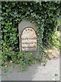
7
Old Milestone by the A4135, High Street, Cam parish
Metal plate attached to stone post by the A4135, in parish of CAM (STROUD District), High Street, between Nos. 38 and 42, on grass verge, on East side of road. Dursley plate, erected by the Berkley & Dursley (Division) turnpike trust in the 19th century.
Inscription reads:-
CAM
GLO'STER 13
DURSLEY 2
WOTTON 6
Grade II listed.
List Entry Number: 1170415 https://historicengland.org.uk/listing/the-list/list-entry/1170415
Milestone Society National ID: GL_WEGL06.
Image: © M Faherty
Taken: 19 Oct 2008
0.04 miles
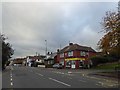
8
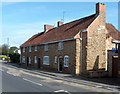
Row of 3 houses, Cam
Numbers 34,36, and 38 High Street are adjacent to the New Life Church http://www.geograph.org.uk/photo/3172989 out of shot on the right.
Image: © Jaggery
Taken: 7 Oct 2012
0.05 miles
9
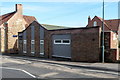
New Life Church, Cam
The full name shown on this church at 32 High Street, Cam, is Dursley, Cam & Wotton New Life Church. The church is part of the Assemblies of God, a Pentecostal movement with c600 churches in Great Britain.
Image: © Jaggery
Taken: 7 Oct 2012
0.07 miles
10
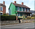
Two wooden-framed semis, Cam
The semi-detached houses are in High Street.
Image: © Jaggery
Taken: 7 Oct 2012
0.07 miles