IMAGES TAKEN NEAR TO
Cam Green, DURSLEY, GL11 5HL
Introduction
This page details the photographs taken nearby to Cam Green, GL11 5HL by members of the Geograph project.
The Geograph project started in 2005 with the aim of publishing, organising and preserving representative images for every square kilometre of Great Britain, Ireland and the Isle of Man.

There are currently over 7.5m images from over14,400 individuals and you can help contribute to the project by visiting https://www.geograph.org.uk
Image Map
Images are licensed for reuse under creativecommons.org/licenses/by-sa/2.0
Notes
- Clicking on the map will re-center to the selected point.
- The higher the marker number, the further away the image location is from the centre of the postcode.
Image Listing (6 Images Found)
Images are licensed for reuse under creativecommons.org/licenses/by-sa/2.0
Image
Details
Distance
1
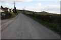
Cam Green
Cam Green with Peaked Down the pyramid shaped hill in the background.
Image: © Philip Halling
Taken: 15 Apr 2012
0.05 miles
2
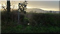
Footpath to Cam
If you fancy a wet muddy trudge across a ploughed field, that is!
Image: © Jonathan Billinger
Taken: 7 Dec 2012
0.06 miles
3
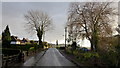
Cam Green
Ribbon development along a country lane near Dursley.
Peaked Down's cone can be seen beyond.
Image: © Jonathan Billinger
Taken: 7 Dec 2012
0.16 miles
4
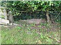
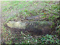
Stone Stile, Upthorpe
A "Fallen Idle" in the parish of Cam, near Dursley, on Gloucestershire footpath CCA60.
In the hedge to the right of the present wooden stile.
Image: © Mr Red
Taken: 18 Jul 2023
0.22 miles
5
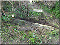
Stone Stile, Upthorpe Farm
The remains of the limestone slab. In the Cam/Upthorpe area of Dursley. This is the view North, the view South is Image
Image: © Mr Red
Taken: 9 Dec 2021
0.22 miles
6
Stone Stile, Upthorpe Farm
The remains of the limestone slab. In the Cam/Upthorpe area of Dursley. This is the view South, the view North is Image
Image: © Mr Red
Taken: 9 Dec 2021
0.22 miles