IMAGES TAKEN NEAR TO
Coaley, DURSLEY, GL11 5DX
Introduction
This page details the photographs taken nearby to GL11 5DX by members of the Geograph project.
The Geograph project started in 2005 with the aim of publishing, organising and preserving representative images for every square kilometre of Great Britain, Ireland and the Isle of Man.

There are currently over 7.5m images from over14,400 individuals and you can help contribute to the project by visiting https://www.geograph.org.uk
Image Map (Loading...)


Getting Data...Please wait
Leaflet Map data © OpenStreetMap
Images are licensed for reuse under creativecommons.org/licenses/by-sa/2.0
Notes
- Clicking on the map will re-center to the selected point.
- The higher the marker number, the further away the image location is from the centre of the postcode.
Image Listing (7 Images Found)
Images are licensed for reuse under creativecommons.org/licenses/by-sa/2.0
Image
Details
Distance
1
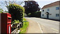
Coaley; postbox and honesty table
Plants for sale in the sleepy village of Coaley.
Image: © Jonathan Billinger
Taken: 27 Jun 2019
0.03 miles
3
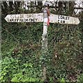
Direction Sign ? Signpost
Located on Peter's Street on the southeast side of junction to Lapley Farm in Coaley parish. 2 arms and ball finial.
Milestone Society National ID: GL_SO7602
Image: © S Kosciow
Taken: 15 Apr 2019
0.10 miles
4
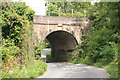
Railway Bridge on the Bristol to Birmingham line
Narrow road under the main Bristol to Birmingham railway.
Image: © roger geach
Taken: 15 Aug 2011
0.14 miles
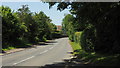
7
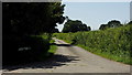
Pinnells End Lane
A dead end lane off Coaley's main street,
Image: © Jonathan Billinger
Taken: 27 Jun 2019
0.25 miles