IMAGES TAKEN NEAR TO
Fiery Lane, DURSLEY, GL11 5DA
Introduction
This page details the photographs taken nearby to Fiery Lane, GL11 5DA by members of the Geograph project.
The Geograph project started in 2005 with the aim of publishing, organising and preserving representative images for every square kilometre of Great Britain, Ireland and the Isle of Man.

There are currently over 7.5m images from over14,400 individuals and you can help contribute to the project by visiting https://www.geograph.org.uk
Image Map
Images are licensed for reuse under creativecommons.org/licenses/by-sa/2.0
Notes
- Clicking on the map will re-center to the selected point.
- The higher the marker number, the further away the image location is from the centre of the postcode.
Image Listing (75 Images Found)
Images are licensed for reuse under creativecommons.org/licenses/by-sa/2.0
Image
Details
Distance
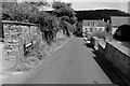
2
A view down Fiery Lane, Uley, Gloucestershire
A slightly foreshortened view down this curiously named lane. In the background is Owlpen Wood.
Image: © Brian Robert Marshall
Taken: 19 May 2007
0.02 miles
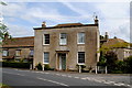
4
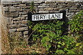
Fiery Lane Sign, Uley, Gloucestershire 2014
Image: © Ray Bird
Taken: 7 Aug 2014
0.06 miles
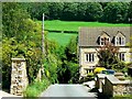
6
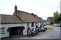
The Old Crown & St Giles Church, Uley, Gloucestershire 2014
Image: © Ray Bird
Taken: 7 Aug 2014
0.08 miles

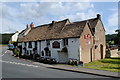
9
No 8 The Green, Uley, Gloucestershire 2014
Grade 2 Listed.
Image: © Ray Bird
Taken: 7 Aug 2014
0.09 miles
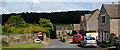
10
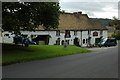
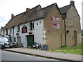
The Old Crown, Uley
Traditional country pub which serves locally brewed real ale. See: http://www.theoldcrownuley.co.uk/
Image: © Philip Halling
Taken: 5 Sep 2009
0.09 miles