
IMAGES TAKEN NEAR TO
Owlpen, DURSLEY, GL11 5BX
Introduction
This page details the photographs taken nearby to GL11 5BX by members of the Geograph project.
The Geograph project started in 2005 with the aim of publishing, organising and preserving representative images for every square kilometre of Great Britain, Ireland and the Isle of Man.

There are currently over 7.5m images from over14,400 individuals and you can help contribute to the project by visiting https://www.geograph.org.uk
Image Map
Images are licensed for reuse under creativecommons.org/licenses/by-sa/2.0
Notes
- Clicking on the map will re-center to the selected point.
- The higher the marker number, the further away the image location is from the centre of the postcode.
Image Listing (5 Images Found)
Images are licensed for reuse under creativecommons.org/licenses/by-sa/2.0
Image
Details
Distance
1
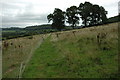
Footpath to Owlpen
Footpath Bencombe across farmland to Owlpen.
Image: © Philip Halling
Taken: 5 Sep 2009
0.10 miles
2
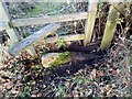
Stone Stiles, Uley
The sunken remnants of a stone tile on the junction of Gloucestershire footpaths CUL63 & COW16 looking NE.
The close-up view looking SE is Image
Image: © Mr Red
Taken: 4 Nov 2022
0.16 miles
3
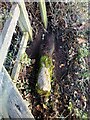
Stone Stiles, Uley
The sunken remnants of a stone tile on the junction of Gloucestershire footpaths CUL63 & COW16 looking SE.
The context view looking NE is Image
Image: © Mr Red
Taken: 4 Nov 2022
0.16 miles
4
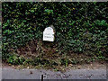
Milestone, Bencombe, nr Uley
In the soil bank in a narrow U/c road without verges (most of its length). Bench Mark below the plate, 136.2 m ASL
Tombstone granite MS with cast metal plate.
Uley ½ / Tetbury 7
Milestone Society ID: GL_TBUL07
Image: © Mr Red
Taken: 22 Sep 2020
0.18 miles
5
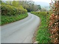
The road to Uley
Uley is a small attractive village quite remotely situated in a valley. None of the roads that lead to it are very straight. This one is no exception.
Image: © Brian Robert Marshall
Taken: 22 Apr 2008
0.19 miles