IMAGES TAKEN NEAR TO
Peak Lane, DURSLEY, GL11 5AT
Introduction
This page details the photographs taken nearby to Peak Lane, GL11 5AT by members of the Geograph project.
The Geograph project started in 2005 with the aim of publishing, organising and preserving representative images for every square kilometre of Great Britain, Ireland and the Isle of Man.

There are currently over 7.5m images from over14,400 individuals and you can help contribute to the project by visiting https://www.geograph.org.uk
Image Map
Images are licensed for reuse under creativecommons.org/licenses/by-sa/2.0
Notes
- Clicking on the map will re-center to the selected point.
- The higher the marker number, the further away the image location is from the centre of the postcode.
Image Listing (5 Images Found)
Images are licensed for reuse under creativecommons.org/licenses/by-sa/2.0
Image
Details
Distance
1
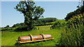
Lower slope of Coaley Peak
Pasture and woodland north of Lever's Hill.
Image: © Jonathan Billinger
Taken: 27 Jun 2019
0.06 miles
2
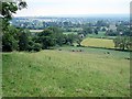
Lever's hill
Looking down Lever's hill from a field adjacent to the road. The building in the distance is Manley house which stands at the end of Silver street (SO 782013)
Image: © Sharon Loxton
Taken: 4 Jul 2006
0.07 miles
3
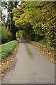
Road up Lever's Hill
Steep narrow country climbing Lever's Hill below the Cotswold escarpment.
Image: © Philip Halling
Taken: 29 Oct 2011
0.16 miles
4
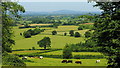
Pastoral view from Lever's Hill
The distinctive dome of May Hill in the distance.
Image: © Jonathan Billinger
Taken: 27 Jun 2019
0.22 miles
5
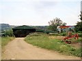
Barn
The barn is on the opposite side of the road to Lower silver street farm, and I believe the red 'contraption' on the right is a threshing machine of some sort.
Image: © Sharon Loxton
Taken: 4 Jul 2006
0.22 miles