IMAGES TAKEN NEAR TO
Tickshill, DURSLEY, GL11 5AP
Introduction
This page details the photographs taken nearby to Tickshill, GL11 5AP by members of the Geograph project.
The Geograph project started in 2005 with the aim of publishing, organising and preserving representative images for every square kilometre of Great Britain, Ireland and the Isle of Man.

There are currently over 7.5m images from over14,400 individuals and you can help contribute to the project by visiting https://www.geograph.org.uk
Image Map (Loading...)


Getting Data...Please wait
Leaflet Map data © OpenStreetMap
Images are licensed for reuse under creativecommons.org/licenses/by-sa/2.0
Notes
- Clicking on the map will re-center to the selected point.
- The higher the marker number, the further away the image location is from the centre of the postcode.
Image Listing (3 Images Found)
Images are licensed for reuse under creativecommons.org/licenses/by-sa/2.0
Image
Details
Distance
1
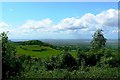
A view near Uley towards the Severn
The landform at the left of the image is Cam Long Down in the next square west. To the right is the River Severn and beyond that the Forest of Dean.
Image: © Brian Robert Marshall
Taken: 19 May 2007
0.20 miles
2
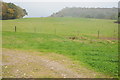
View to Cam Long Down
View to Cam Long Down from the north, at the time rain was falling thus the mist partially obscuring the view.
Image: © Philip Halling
Taken: 29 Oct 2011
0.22 miles