IMAGES TAKEN NEAR TO
Harrolds Close, DURSLEY, GL11 4FD
Introduction
This page details the photographs taken nearby to Harrolds Close, GL11 4FD by members of the Geograph project.
The Geograph project started in 2005 with the aim of publishing, organising and preserving representative images for every square kilometre of Great Britain, Ireland and the Isle of Man.

There are currently over 7.5m images from over14,400 individuals and you can help contribute to the project by visiting https://www.geograph.org.uk
Image Map
Images are licensed for reuse under creativecommons.org/licenses/by-sa/2.0
Notes
- Clicking on the map will re-center to the selected point.
- The higher the marker number, the further away the image location is from the centre of the postcode.
Image Listing (200 Images Found)
Images are licensed for reuse under creativecommons.org/licenses/by-sa/2.0
Image
Details
Distance
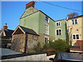
4
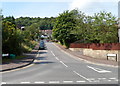
Henlow Drive, Dursley
Viewed from the A4135, here named Bull Pitch.
Image: © Jaggery
Taken: 21 Jul 2012
0.09 miles
7
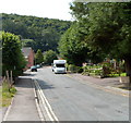
May Lane south of Hill Road, Dursley
Looking towards Five Acres.
Image: © Jaggery
Taken: 21 Jul 2012
0.09 miles
9
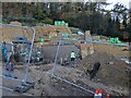
Gabion retaining structure
Large gabions containing Cotswold stone built high in order to protect the new build on a steep hillside.
Image: © don cload
Taken: 22 Nov 2022
0.10 miles