
IMAGES TAKEN NEAR TO
Kingshill Road, DURSLEY, GL11 4EJ
Introduction
This page details the photographs taken nearby to Kingshill Road, GL11 4EJ by members of the Geograph project.
The Geograph project started in 2005 with the aim of publishing, organising and preserving representative images for every square kilometre of Great Britain, Ireland and the Isle of Man.

There are currently over 7.5m images from over14,400 individuals and you can help contribute to the project by visiting https://www.geograph.org.uk
Image Map
Images are licensed for reuse under creativecommons.org/licenses/by-sa/2.0
Notes
- Clicking on the map will re-center to the selected point.
- The higher the marker number, the further away the image location is from the centre of the postcode.
Image Listing (26 Images Found)
Images are licensed for reuse under creativecommons.org/licenses/by-sa/2.0
Image
Details
Distance
1
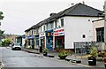
Parade of shops, Kingshill Parade, Kingshill Road, Dursley, Glos
A parade of shops located next to the Oak at Kingshill public house/restaurant. The parade includes takeaways.
Image: © P L Chadwick
Taken: 12 Jul 2021
0.01 miles
2
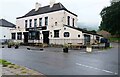
Oak at Kingshill (1), 2 Kingshill Road, Dursley, Glos
A family run public house and restaurant. In the past it has been known as Ranchers Steakhouse and Kingshill Inn.
Image
Image
Image: © P L Chadwick
Taken: 12 Jul 2021
0.01 miles
3
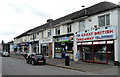
Kingshill Road shops, Dursley
The three shops nearest the camera are all food takeaways.
Image: © Jaggery
Taken: 21 Jul 2012
0.02 miles
4
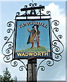
The Kingshill name sign, Dursley
The sign, and a flourish of metalwork, is on a post in a strip of grass alongside this http://www.geograph.org.uk/photo/3317975 pub.
Image: © Jaggery
Taken: 21 Jul 2012
0.02 miles
5
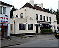
The Kingshill, Dursley
The pub is at the NW end of a row of Kingshill Road shops. http://www.geograph.org.uk/photo/3317887
Image: © Jaggery
Taken: 21 Jul 2012
0.02 miles
6
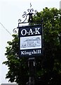
Oak at Kingshill (2) - sign, 2 Kingshill Road, Dursley, Glos
The sign shows a black and white drawing of the building. It is set on a post near the main road.
Image
Image
Image: © P L Chadwick
Taken: 12 Jul 2021
0.03 miles
7
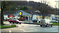
Lidl supermarket, Kingshill, Dursley
In the shadow of Sheep's Path Wood on the northern flank of Stinchcombe Hill.
Image: © Jonathan Billinger
Taken: 7 Dec 2012
0.03 miles
8
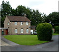
St Dominic's presbytery, Dursley
The presbytery (priests' house) was built in 1954 on the north side of the church http://www.geograph.org.uk/photo/3317860
Image: © Jaggery
Taken: 21 Jul 2012
0.03 miles
9
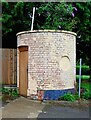
Oak at Kingshill (3) - outbuilding, 2 Kingshill Road, Dursley, Glos
This outbuilding is to be found in the car park of the Oak at Kingshill public house and restaurant. At a guess, and that is all it can be, it might just be an icehouse. Before refrigerators were invented, icehouses were built to store ice and insulating materials. Often the main purpose was to store foods or to keep drinks cool.
Image
Image
Image: © P L Chadwick
Taken: 12 Jul 2021
0.04 miles
10
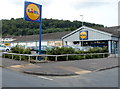
Lidl, Dursley
The Lidl site occupies all of the NW side of Kings Drive. Viewed from the corner of Kingshill Road looking towards Jubilee Road.
Image: © Jaggery
Taken: 21 Jul 2012
0.04 miles