IMAGES TAKEN NEAR TO
Arthurs Yard, Tinkley Lane, STONEHOUSE, GL10 3UZ
Introduction
This page details the photographs taken nearby to Arthurs Yard, Tinkley Lane, GL10 3UZ by members of the Geograph project.
The Geograph project started in 2005 with the aim of publishing, organising and preserving representative images for every square kilometre of Great Britain, Ireland and the Isle of Man.

There are currently over 7.5m images from over14,400 individuals and you can help contribute to the project by visiting https://www.geograph.org.uk
Image Map
Images are licensed for reuse under creativecommons.org/licenses/by-sa/2.0
Notes
- Clicking on the map will re-center to the selected point.
- The higher the marker number, the further away the image location is from the centre of the postcode.
Image Listing (105 Images Found)
Images are licensed for reuse under creativecommons.org/licenses/by-sa/2.0
Image
Details
Distance
1
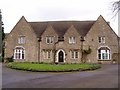
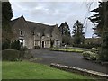
Marist Convent
Catholic Convent in the heart of Nympsfield
Image: © Bob Woodman
Taken: Unknown
0.05 miles
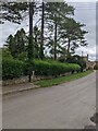
2
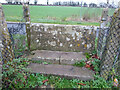
Stone Stile, Nympsfield
Looking out across the field to Tinkley Lane and another stone stile. The RC Primary School playing field is behind the camera. The view looking back (SW) is Image
Image: © Mr Red
Taken: 15 Dec 2021
0.06 miles
3
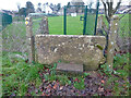
Stone Stile, Nympsfield
Looking in to the RC Primary School playing field. The view looking out (NE to Tinkley Lane) is Image
Image: © Mr Red
Taken: 15 Dec 2021
0.06 miles
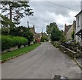
5
Hedges and trees, Nympsfield, Gloucestershire
Viewed across Front Street in August 2021.
A red phonebox https://www.geograph.org.uk/photo/6940133 is in the background.
Image: © Jaggery
Taken: 15 Aug 2021
0.08 miles
6
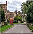
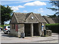
Red phonebox, Front Street, Nympsfield, Gloucestershire
Grade II Listed K6 phonebox viewed in August 2021.
Image: © Jaggery
Taken: 15 Aug 2021
0.08 miles
7
Front Street, Nympsfield, Gloucestershire
Looking east towards this https://www.geograph.org.uk/photo/6940133 red phonebox.
Image: © Jaggery
Taken: 15 Aug 2021
0.08 miles
8
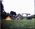
Fields by footpath at Nympsfield
Public footpaths pass this field at Nympsfield. Modern building on right is St Joseph's Primary School. Just visible in background is what is now the Rose and Crown Public House. A friendly farmer permitted camping in his field here when we were walking the Cotswold Way.
Image: © Clint Mann
Taken: 19 Aug 1980
0.08 miles
10
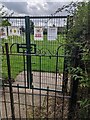
Gates at the edge of St Joseph's churchyard, Nympsfield, Gloucestershire
Formerly(?) giving access from the churchyard to St Joseph's Catholic Primary School. Notices in view in August 2021 include "Please no entering" and "No parents beyond this point"
Image: © Jaggery
Taken: 15 Aug 2021
0.08 miles