IMAGES TAKEN NEAR TO
Sperry Way, STONEHOUSE, GL10 3UT
Introduction
This page details the photographs taken nearby to Sperry Way, GL10 3UT by members of the Geograph project.
The Geograph project started in 2005 with the aim of publishing, organising and preserving representative images for every square kilometre of Great Britain, Ireland and the Isle of Man.

There are currently over 7.5m images from over14,400 individuals and you can help contribute to the project by visiting https://www.geograph.org.uk
Image Map
Images are licensed for reuse under creativecommons.org/licenses/by-sa/2.0
Notes
- Clicking on the map will re-center to the selected point.
- The higher the marker number, the further away the image location is from the centre of the postcode.
Image Listing (91 Images Found)
Images are licensed for reuse under creativecommons.org/licenses/by-sa/2.0
Image
Details
Distance
1

Three businesses in Stonehouse Park, Stonehouse
Feel Complete on the left, Edgeworth & Co Ltd in the middle and Blueberry on the right are three of many businesses in Stonehouse Park.
Image: © Jaggery
Taken: 20 Nov 2022
0.01 miles
2

Tony Gee office, Stonehouse
The Stonehouse Park premises of Tony Gee and Partners LLP viewed from Sperry Way.
Image: © Jaggery
Taken: 20 Nov 2022
0.02 miles
3

Blueberry and IFS, Stonehouse Park, Stonehouse
Blueberry Systems Ltd (bespoke software designer) on the left.
IFS Payroll Services on the right.
Image: © Jaggery
Taken: 20 Nov 2022
0.02 miles
4

Sanctus House, Stonehouse
In Stonehouse Park, a business park accessed from the A419.
Image: © Jaggery
Taken: 20 Nov 2022
0.03 miles
5
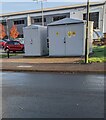
Two grey cabinets, Sperry Way, Stonehouse
The label on the smaller cabinet shows "IDNO LV FUSE CABINET" and "ESP ELECTRICITY". The larger cabinet is a Western Power Distribution electricity substation. Its identifier is S/S 795662
Image: © Jaggery
Taken: 20 Nov 2022
0.03 miles
6
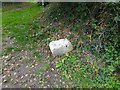
Boundary Stone, Stroudwater
To the right of the track down to Bonds Mill Cottages. Defining the limit of jurisdiction of the canal (aka navigation). If it had once had an inscription it would have been S W N.
Milestone Society National ID: GL_STWSTO01em
Image: © Mr Red
Taken: 14 Oct 2021
0.03 miles
7

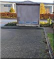
Stonehouse Park electricity substation, Stonehouse
Western Power Distribution electricity substation alongside Sperry Way.
Its identifier is STONEHOUSE PARK S/S 01225.
Image: © Jaggery
Taken: 20 Nov 2022
0.03 miles
8

Electric vehicle recharging area, Stonehouse
In Stonehouse Park, a business park accessed from the A419.
Image: © Jaggery
Taken: 20 Nov 2022
0.04 miles
9

Connexus, Stonehouse
In November 2022 text on the wall of the Connexus premises includes "Leaders In Training"
Image: © Jaggery
Taken: 20 Nov 2022
0.04 miles
10
Rear of an electricity substation, Sperry Way, Stonehouse
The back of this https://www.geograph.org.uk/photo/7348162 electricity substation.
Image: © Jaggery
Taken: 20 Nov 2022
0.04 miles