IMAGES TAKEN NEAR TO
Nupend, STONEHOUSE, GL10 3SS
Introduction
This page details the photographs taken nearby to GL10 3SS by members of the Geograph project.
The Geograph project started in 2005 with the aim of publishing, organising and preserving representative images for every square kilometre of Great Britain, Ireland and the Isle of Man.

There are currently over 7.5m images from over14,400 individuals and you can help contribute to the project by visiting https://www.geograph.org.uk
Image Map
Images are licensed for reuse under creativecommons.org/licenses/by-sa/2.0
Notes
- Clicking on the map will re-center to the selected point.
- The higher the marker number, the further away the image location is from the centre of the postcode.
Image Listing (6 Images Found)
Images are licensed for reuse under creativecommons.org/licenses/by-sa/2.0
Image
Details
Distance
1
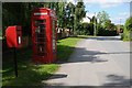
Telephone box and postbox
Telephone box and postbox in Nupend, though it doesn't appear there is a telephone here anymore.
Image: © Philip Halling
Taken: 8 Jun 2015
0.03 miles
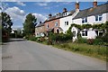
4

No through road, Nupend
A no through road giving access to a few houses, cottages and a farm in the hamlet of Nupend.
Image: © Philip Halling
Taken: 8 Jun 2015
0.14 miles
5
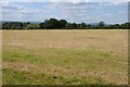
Harvested silage field, Nupend
View to the north-west across a harvested silage field at Nupend. The high ground of the Forest of Dean can be seen, including May Hill, on the horizon.
Image: © Philip Halling
Taken: 8 Jun 2015
0.21 miles
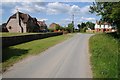
6
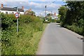
Road at Nupend
Country road entering the hamlet of Nupend.
Image: © Philip Halling
Taken: 8 Jun 2015
0.22 miles