IMAGES TAKEN NEAR TO
Millend, STONEHOUSE, GL10 3SF
Introduction
This page details the photographs taken nearby to Millend, GL10 3SF by members of the Geograph project.
The Geograph project started in 2005 with the aim of publishing, organising and preserving representative images for every square kilometre of Great Britain, Ireland and the Isle of Man.

There are currently over 7.5m images from over14,400 individuals and you can help contribute to the project by visiting https://www.geograph.org.uk
Image Map
Images are licensed for reuse under creativecommons.org/licenses/by-sa/2.0
Notes
- Clicking on the map will re-center to the selected point.
- The higher the marker number, the further away the image location is from the centre of the postcode.
Image Listing (12 Images Found)
Images are licensed for reuse under creativecommons.org/licenses/by-sa/2.0
Image
Details
Distance
1
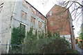
Millend Mill (circa 1820) Eastington
Millend Mill November 2007. The lighter coloured Cotswold stone building dates from around 1820; the darker red brick building is much later.
The mill is unused as at November 2007
Image: © Mark Jones
Taken: Unknown
0.02 miles
2
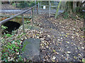
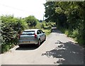
Stone Stile, Eastington
The remains of a stile off Millend Lane leading to Stonehouse Ocean. The View looking towards Stonehouse is Image
Image: © Mr Red
Taken: 12 Dec 2021
0.10 miles
3
Stone Stile, Eastington
The remains of a stile off Millend Lane leading to Stonehouse Ocean. The View looking back to the road is Image
Image: © Mr Red
Taken: 12 Dec 2021
0.10 miles
4
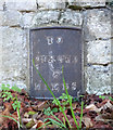
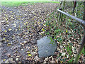
Old Milestone, Spring Hill
Milestone set in the wall of Eastington lodge. More milestones in the area see http://umap.openstreetmap.fr/en/map/stonehouse-milestones_519080#14/51.7521/-2.2960
Stroud 5
Milestone Society National ID: GL_SDGL05
Image: © Mr Red
Taken: 2 Nov 2018
0.17 miles
5

Triangular road markings on the approach to a speed limit change in Eastington
Ahead, the speed limit along Spring Hill reduces from 40mph to 30mph.
Image: © Jaggery
Taken: 29 Jun 2014
0.19 miles
6

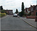
Spring Hill houses in Eastington
Viewed across Spring Hill looking towards the corner of Bradestones Way. http://www.geograph.org.uk/photo/4048358
Image: © Jaggery
Taken: 29 Jun 2014
0.19 miles
7
Middlecroft, Eastington
Cul-de-sac on the south side of Millend Lane.
Image: © Jaggery
Taken: 29 Jun 2014
0.20 miles
8
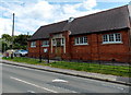
Eastington Village Hall
Viewed across Alkerton Road. The foundation stones are dated June 15th 1927.
Image: © Jaggery
Taken: 29 Jun 2014
0.21 miles
9
Millend Lane towards Millend, Eastington
Millend Lane heads SW away from the Anglican church http://www.geograph.org.uk/photo/4052434 and village school.
Image: © Jaggery
Taken: 29 Jun 2014
0.22 miles
10

Bradestones Way, Eastington
Viewed across Spring Hill.
Image: © Jaggery
Taken: 29 Jun 2014
0.22 miles