IMAGES TAKEN NEAR TO
Brunel Way, STONEHOUSE, GL10 3RU
Introduction
This page details the photographs taken nearby to Brunel Way, GL10 3RU by members of the Geograph project.
The Geograph project started in 2005 with the aim of publishing, organising and preserving representative images for every square kilometre of Great Britain, Ireland and the Isle of Man.

There are currently over 7.5m images from over14,400 individuals and you can help contribute to the project by visiting https://www.geograph.org.uk
Image Map
Images are licensed for reuse under creativecommons.org/licenses/by-sa/2.0
Notes
- Clicking on the map will re-center to the selected point.
- The higher the marker number, the further away the image location is from the centre of the postcode.
Image Listing (61 Images Found)
Images are licensed for reuse under creativecommons.org/licenses/by-sa/2.0
Image
Details
Distance
1
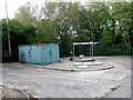
Sewage Plant at Newtown
Most of this area on the western side of Newtown is industrial and commercial and this small sewage plant sits next to the A419.
Image: © Nigel Mykura
Taken: 7 Oct 2011
0.06 miles
3
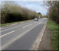
A419, Newtown, Gloucestershire
This part of the A419 is between Stonehouse and M5 Motorway junction 13 (ahead).
Image: © Jaggery
Taken: 1 Apr 2018
0.07 miles
5
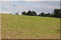
Field of maize
Field of maize which is just emerging from the soil, a chimney and business unit on the Oldends industrial estate can be seen in the background.
Image: © Philip Halling
Taken: 8 Jun 2015
0.10 miles
6
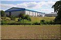
Industrial unit at Nastends
Industrial unit at Nastends viewed from a footpath on adjacent farmland.
Image: © Philip Halling
Taken: 8 Jun 2015
0.10 miles
7
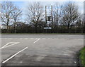
Junction in Newtown, Gloucestershire
Old Bristol Road joins the A419 Bristol Road. Left for Gloucester, right for Stroud.
Image: © Jaggery
Taken: 1 Apr 2018
0.11 miles
8
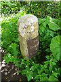
Milestone, Newtown nr Stonehouse
Actually (just) in the parish of Eastington. At the end of housing on the old A419, Bristol Rd. Now a cycle track. More milestones in the area see http://umap.openstreetmap.fr/en/map/stonehouse-milestones_519080#14/51.7521/-2.2960
Stroud 4
Milestone Society National ID: GL_SDGL04
Image: © Mr Red
Taken: 10 May 2018
0.12 miles
9
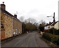
Old Bristol Road, Newtown near Stonehouse
Viewed past Beech Cottage. This quiet side road used to be part
of Bristol Road, which now follows a straighter route nearby.
Image: © Jaggery
Taken: 24 Mar 2013
0.12 miles
10
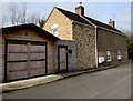
Beech Cottage, Old Bristol Road, Newtown near Stonehouse
Alongside a side road formerly part of Bristol Road which now follows a straighter route nearby.
Image: © Jaggery
Taken: 1 Apr 2018
0.12 miles