IMAGES TAKEN NEAR TO
Nastend, STONEHOUSE, GL10 3RP
Introduction
This page details the photographs taken nearby to GL10 3RP by members of the Geograph project.
The Geograph project started in 2005 with the aim of publishing, organising and preserving representative images for every square kilometre of Great Britain, Ireland and the Isle of Man.

There are currently over 7.5m images from over14,400 individuals and you can help contribute to the project by visiting https://www.geograph.org.uk
Image Map
Images are licensed for reuse under creativecommons.org/licenses/by-sa/2.0
Notes
- Clicking on the map will re-center to the selected point.
- The higher the marker number, the further away the image location is from the centre of the postcode.
Image Listing (50 Images Found)
Images are licensed for reuse under creativecommons.org/licenses/by-sa/2.0
Image
Details
Distance
1
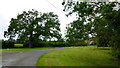
Nastend Green
Very green in the wet early summer of 2012.
Image: © Jonathan Billinger
Taken: 15 Jun 2012
0.04 miles
2
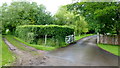
Track from Nastend Lane
The drive to Nastend Court, private, to the right; public track to the left.
Image: © Jonathan Billinger
Taken: 15 Jun 2012
0.04 miles
3
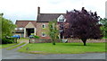
Nastend Green Farm
A fine young copper beech to the right.
Image: © Jonathan Billinger
Taken: 15 Jun 2012
0.07 miles
4
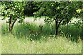
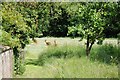
Roe deer near Nastend Green Farm
Red deer (Cervus elaphus) to the rear of Nastend Green Farm.
Image: © Philip Halling
Taken: 8 Jun 2015
0.09 miles
5
On the run...
After watching me for a few moments these roe deer are off.
Image: © Philip Halling
Taken: 8 Jun 2015
0.09 miles
6
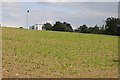
Field of maize
Field of maize which is just emerging from the soil, a chimney and business unit on the Oldends industrial estate can be seen in the background.
Image: © Philip Halling
Taken: 8 Jun 2015
0.13 miles
7
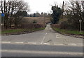
Nastend Lane near Stonehouse
Viewed across the A419. Not a through route, Nastend Lane heads NE towards Nastend Farm.
Image: © Jaggery
Taken: 24 Mar 2013
0.15 miles
8

Industrial unit at Nastends
Industrial unit at Nastends viewed from a footpath on adjacent farmland.
Image: © Philip Halling
Taken: 8 Jun 2015
0.16 miles
9
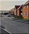
21st century houses, John Wothers Lane, Great Oldbury, Gloucestershire
Recently built houses viewed in November 2021.
Image: © Jaggery
Taken: 7 Nov 2021
0.16 miles
10
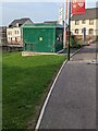
Nastend View electricity substation, Great Oldbury, Gloucestershire
The green cabinet alongside Great Oldbury Drive is a Western Power Distribution electricity substation. Its identifier is S/S 795983 NASTEND VIEW.
Image: © Jaggery
Taken: 7 Nov 2021
0.18 miles