IMAGES TAKEN NEAR TO
Newtown, STONEHOUSE, GL10 3RN
Introduction
This page details the photographs taken nearby to GL10 3RN by members of the Geograph project.
The Geograph project started in 2005 with the aim of publishing, organising and preserving representative images for every square kilometre of Great Britain, Ireland and the Isle of Man.

There are currently over 7.5m images from over14,400 individuals and you can help contribute to the project by visiting https://www.geograph.org.uk
Image Map
Images are licensed for reuse under creativecommons.org/licenses/by-sa/2.0
Notes
- Clicking on the map will re-center to the selected point.
- The higher the marker number, the further away the image location is from the centre of the postcode.
Image Listing (86 Images Found)
Images are licensed for reuse under creativecommons.org/licenses/by-sa/2.0
Image
Details
Distance
1
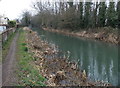
Canal and path towards Roving Bridge, Newtown
Looking SSE along the Stroudwater Canal. Roving Bridge can be seen in the distance.
Image: © Jaggery
Taken: 24 Mar 2013
0.04 miles
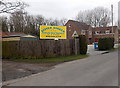
2
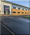
Building at the NW end of Sperry Way, Stonehouse
Part of Stonehouse Park (a business park) accessed from the A419.
Image: © Jaggery
Taken: 20 Nov 2022
0.05 miles
3
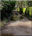
Puddly lane in Newtown near Stonehouse
Viewed on Easter Sunday April 1st 2018.
Image: © Jaggery
Taken: 1 Apr 2018
0.06 miles
4
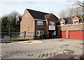
Little Angels Nursery in Newtown near Stonehouse
Private day nursery for pre-school children in Hollybrooke House.
Image: © Jaggery
Taken: 1 Apr 2018
0.08 miles
5
Little Angels in Newtown
Private day nursery for pre-school children in Hollybrooke House in Newtown near Stonehouse.
Image: © Jaggery
Taken: 24 Mar 2013
0.08 miles
6
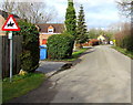
Warning sign - horse riders, Old Bristol Road, Newtown near Stonehouse
Alongside a side road formerly part of Bristol Road which now follows a straighter route nearby.
Image: © Jaggery
Taken: 1 Apr 2018
0.09 miles
7
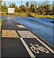
End of cycle lane, Sperry Way, Stonehouse
Near the dead end of Sperry Way.
Image: © Jaggery
Taken: 20 Nov 2022
0.09 miles
8
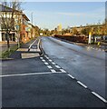
NW along Sperry Way, Stonehouse
Connecting with the A419 behind the camera, dead-end Sperry Way is the main road through Stonehouse Park (a business park).
Image: © Jaggery
Taken: 20 Nov 2022
0.09 miles
9
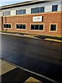
GCSD premises, Sperry Way, Stonehouse
In November 2022 the nameboard shows "GCSD Xeinadin Group"
Image: © Jaggery
Taken: 20 Nov 2022
0.09 miles
10
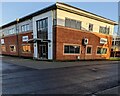
Enverus, Stonehouse
Enverus premises in Stonehouse Park, a business park accessed from the A419.
Image: © Jaggery
Taken: 20 Nov 2022
0.09 miles