IMAGES TAKEN NEAR TO
Gipsy Lane, STONEHOUSE, GL10 3PE
Introduction
This page details the photographs taken nearby to Gipsy Lane, GL10 3PE by members of the Geograph project.
The Geograph project started in 2005 with the aim of publishing, organising and preserving representative images for every square kilometre of Great Britain, Ireland and the Isle of Man.

There are currently over 7.5m images from over14,400 individuals and you can help contribute to the project by visiting https://www.geograph.org.uk
Image Map
Images are licensed for reuse under creativecommons.org/licenses/by-sa/2.0
Notes
- Clicking on the map will re-center to the selected point.
- The higher the marker number, the further away the image location is from the centre of the postcode.
Image Listing (4 Images Found)
Images are licensed for reuse under creativecommons.org/licenses/by-sa/2.0
Image
Details
Distance
1
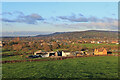
Leaze Farm
Leaze Farm seen from the field footpath.
Image: © Wayland Smith
Taken: 5 Dec 2020
0.01 miles
2
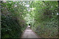
Woodside Lane
A sunken lane leading from Frocester Hill towards King's Stanley
Image: © Tim Heaton
Taken: 6 Jul 2017
0.20 miles
3
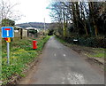
Gipsy Lane, Leonard Stanley
Looking past the edge of Church Farm towards Leaze Farm and Sandford's Knoll.
Image: © Jaggery
Taken: 23 Mar 2014
0.23 miles
4
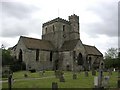
Leonard Stanley (Glos) Priory Church
Dedicated to St Swithun, remains of the domestic buildings are incorporated in nearby farm buildings.
Image: © ChurchCrawler
Taken: Unknown
0.24 miles