IMAGES TAKEN NEAR TO
Dozule Close, STONEHOUSE, GL10 3NL
Introduction
This page details the photographs taken nearby to Dozule Close, GL10 3NL by members of the Geograph project.
The Geograph project started in 2005 with the aim of publishing, organising and preserving representative images for every square kilometre of Great Britain, Ireland and the Isle of Man.

There are currently over 7.5m images from over14,400 individuals and you can help contribute to the project by visiting https://www.geograph.org.uk
Image Map
Images are licensed for reuse under creativecommons.org/licenses/by-sa/2.0
Notes
- Clicking on the map will re-center to the selected point.
- The higher the marker number, the further away the image location is from the centre of the postcode.
Image Listing (47 Images Found)
Images are licensed for reuse under creativecommons.org/licenses/by-sa/2.0
Image
Details
Distance
1
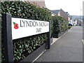
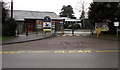
A thankful estate
The new housing estate in Leonard Stanley has a number of roads, the signage of which have a poppy on them.
Image: © Neil Owen
Taken: 7 Feb 2023
0.10 miles
2
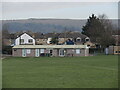
Leonard Stanley changing rooms
The village football team plays here.
Image: © Neil Owen
Taken: 7 Feb 2023
0.11 miles
3
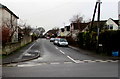
Mankley Road, Leonard Stanley
From Bath Road along Mankley Road towards Marsh Road. According to one online source,
this is the only Mankley (Road or Street or Avenue or Crescent etc) in the UK.
Image: © Jaggery
Taken: 22 Dec 2017
0.15 miles
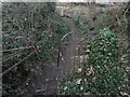
4
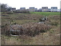
Balancing pond in Leonard Stanley
New houses surround the stream, so a balancing pond is something of a necessity. It also provides a chance for some wetland plants to gain a foothold.
Image: © Neil Owen
Taken: 7 Feb 2023
0.17 miles
5
Entrance to Leonard Stanley Church of England Primary School
This entrance is from Bath Road, Leonard Stanley.
Image: © Jaggery
Taken: 22 Dec 2017
0.17 miles
6
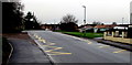
Zigzag yellow markings on Bath Road, Leonard Stanley
Marking the Keep Clear Zone near the entrance https://www.geograph.org.uk/photo/5632766 to Leonard Stanley Church of England Primary School.
Image: © Jaggery
Taken: 22 Dec 2017
0.18 miles
7
A remnant of when this was all fields
New housing has radically increased the population of Leonard Stanley. The programme of new builds by the local council has put nearly £20 million into creating homes here in recent years. However, a relic of a bygone age still remains on the old footpath - a rusty fence and stile.
Image: © Neil Owen
Taken: 7 Feb 2023
0.19 miles
8

Leonard Stanley
Cottages near Leonard Stanley church.
Image: © Philip Halling
Taken: 29 Oct 2011
0.19 miles
9
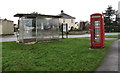
Bus shelter and red phonebox, Bath Road, Leonard Stanley
Located between the Brockley Road junction and the Brimley junction.
Image: © Jaggery
Taken: 22 Dec 2017
0.19 miles
10
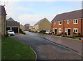
Dyehouse Field, King's Stanley
Houses built on a greenfield site in the second decade of the 21st century.
Image: © Jaggery
Taken: 22 Dec 2017
0.20 miles