IMAGES TAKEN NEAR TO
Brimley, STONEHOUSE, GL10 3LZ
Introduction
This page details the photographs taken nearby to Brimley, GL10 3LZ by members of the Geograph project.
The Geograph project started in 2005 with the aim of publishing, organising and preserving representative images for every square kilometre of Great Britain, Ireland and the Isle of Man.

There are currently over 7.5m images from over14,400 individuals and you can help contribute to the project by visiting https://www.geograph.org.uk
Image Map
Images are licensed for reuse under creativecommons.org/licenses/by-sa/2.0
Notes
- Clicking on the map will re-center to the selected point.
- The higher the marker number, the further away the image location is from the centre of the postcode.
Image Listing (80 Images Found)
Images are licensed for reuse under creativecommons.org/licenses/by-sa/2.0
Image
Details
Distance
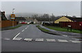
1
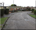
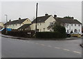
Bend in Brimley, Leonard Stanley
The road named Brimley follows a roughly semicircular route on the east side of Bath Road.
Image: © Jaggery
Taken: 22 Dec 2017
0.05 miles
2
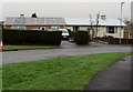
Metal framed bungalows, Brimley, Leonard Stanley
The wall of the bungalow on the left is clad in brick in December 2017.
Image: © Jaggery
Taken: 22 Dec 2017
0.07 miles
3
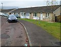
Beeches Close bungalows, King's Stanley
This side of the street is named Beeches Close. The opposite side, out of shot, is The Beeches.
Image: © Jaggery
Taken: 20 Nov 2011
0.07 miles
4
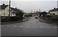
Brimley, Leonard Stanley
The southeast part of Brimley viewed across Bath Road.
The course of the Brimley roadway is roughly semicircular.
It rejoins Bath Road 175 metres to the northwest.
Image: © Jaggery
Taken: 22 Dec 2017
0.08 miles
5
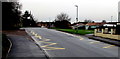
Zigzag yellow markings on Bath Road, Leonard Stanley
Marking the Keep Clear Zone near the entrance https://www.geograph.org.uk/photo/5632766 to Leonard Stanley Church of England Primary School.
Image: © Jaggery
Taken: 22 Dec 2017
0.09 miles
6
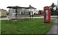
Bus shelter and red phonebox, Bath Road, Leonard Stanley
Located between the Brockley Road junction and the Brimley junction.
Image: © Jaggery
Taken: 22 Dec 2017
0.10 miles
7
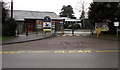
Entrance to Leonard Stanley Church of England Primary School
This entrance is from Bath Road, Leonard Stanley.
Image: © Jaggery
Taken: 22 Dec 2017
0.10 miles
8
Corner of Bath Road and Brimley, Leonard Stanley
Viewed across Bath Road. This is one of two junctions of Bath Road and Brimley https://www.geograph.org.uk/photo/5632760 in Leonard Stanley. The other one is 175 metres away.
Image: © Jaggery
Taken: 22 Dec 2017
0.10 miles
9
Brockley Road, Leonard Stanley
Viewed across Bath Road.
Image: © Jaggery
Taken: 22 Dec 2017
0.10 miles
10
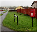
Queen Elizabeth II postbox, Brockley Road, Leonard Stanley
On the right here https://www.geograph.org.uk/photo/5632808 on the corner of Bath Road.
Image: © Jaggery
Taken: 22 Dec 2017
0.11 miles