IMAGES TAKEN NEAR TO
Borough Close, STONEHOUSE, GL10 3LJ
Introduction
This page details the photographs taken nearby to Borough Close, GL10 3LJ by members of the Geograph project.
The Geograph project started in 2005 with the aim of publishing, organising and preserving representative images for every square kilometre of Great Britain, Ireland and the Isle of Man.

There are currently over 7.5m images from over14,400 individuals and you can help contribute to the project by visiting https://www.geograph.org.uk
Image Map
Images are licensed for reuse under creativecommons.org/licenses/by-sa/2.0
Notes
- Clicking on the map will re-center to the selected point.
- The higher the marker number, the further away the image location is from the centre of the postcode.
Image Listing (101 Images Found)
Images are licensed for reuse under creativecommons.org/licenses/by-sa/2.0
Image
Details
Distance
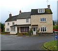
1
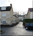
The Luggs, King's Stanley
Dead-end street on the south side of the High Street, Castle Street and Shute Street crossroads.
Image: © Jaggery
Taken: 22 Dec 2017
0.06 miles
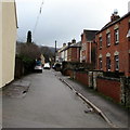
2
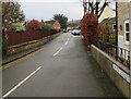
East along Shute Street, King's Stanley
Towards New Street and Broad Street.
Image: © Jaggery
Taken: 22 Dec 2017
0.06 miles
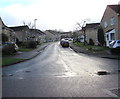
3
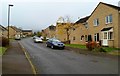
Borough Close, King's Stanley
Viewed from the northern (Castle Street) end of a long cul-de-sac containing about 70 houses.
Image: © Jaggery
Taken: 20 Nov 2011
0.07 miles
4
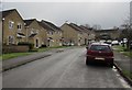
Up Borough Close, King's Stanley
Borough Close ascends from Castle Street.
Image: © Jaggery
Taken: 22 Dec 2017
0.07 miles
5
Corner of The Luggs and Shute Street, King's Stanley
The street name sign for The Luggs is at the right edge of the view.
The Shute Street name sign is low down on the left, above the painted triangle on the road surface.
On the wall of the house on the left is a three-row inscription showing
B WB 1790.
Image: © Jaggery
Taken: 20 Nov 2011
0.07 miles
6
New Street, King's Stanley
From Broad Street along New Street towards Shute Street.
Image: © Jaggery
Taken: 22 Dec 2017
0.08 miles
7
Borough Close, King's Stanley
The northwest part of a long cul-de-sac viewed from Castle Street.
Image: © Jaggery
Taken: 22 Dec 2017
0.08 miles
8
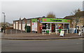
Co-op food store and village post office, King's Stanley
The Co-operative Food store is located on the corner of High Street and Bath Road.
The post office opened inside the store in the spring of 2010. Previously, the village post office was a few metres away, on the opposite side of High Street.
Image: © Jaggery
Taken: 20 Nov 2011
0.08 miles
9
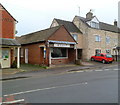
Tony's butchers, King's Stanley
High Street butchers, greengrocery and delicatessen.
Image: © Jaggery
Taken: 20 Nov 2011
0.08 miles
10
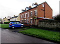
Row of three brick houses, Castle Street, King's Stanley
Located between Borough Close and The Luggs. http://www.geograph.org.uk/photo/5633267
Image: © Jaggery
Taken: 22 Dec 2017
0.08 miles