IMAGES TAKEN NEAR TO
Castle Street, STONEHOUSE, GL10 3JZ
Introduction
This page details the photographs taken nearby to Castle Street, GL10 3JZ by members of the Geograph project.
The Geograph project started in 2005 with the aim of publishing, organising and preserving representative images for every square kilometre of Great Britain, Ireland and the Isle of Man.

There are currently over 7.5m images from over14,400 individuals and you can help contribute to the project by visiting https://www.geograph.org.uk
Image Map
Images are licensed for reuse under creativecommons.org/licenses/by-sa/2.0
Notes
- Clicking on the map will re-center to the selected point.
- The higher the marker number, the further away the image location is from the centre of the postcode.
Image Listing (92 Images Found)
Images are licensed for reuse under creativecommons.org/licenses/by-sa/2.0
Image
Details
Distance
1
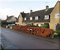
Woodland View, Castle Street, King's Stanley
The name sign in the brown hedge shows WOODLAND VIEW.
Image: © Jaggery
Taken: 22 Dec 2017
0.01 miles
2
Corner of Castle Street and Castle Mead, King's Stanley
Viewed across Castle Street.
Image: © Jaggery
Taken: 20 Nov 2011
0.02 miles
3
Rose Terrace, King's Stanley
From Castle Street, Rose Terrace leads to Ash Close.
Image: © Jaggery
Taken: 22 Dec 2017
0.02 miles
4
Start of the 30 zone in King's Stanley
The National Speed Limit on Woodside Lane drops to 30mph
on the approach to Castle Street towards the centre of the village.
Image: © Jaggery
Taken: 22 Dec 2017
0.02 miles
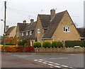
5
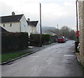
Castle Street, King's Stanley
This part of Castle Street is between the Borough Close junction and the Castle Mead junction.
Image: © Jaggery
Taken: 22 Dec 2017
0.02 miles
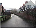
6
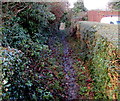
Public footpath in King's Stanley
This public footpath is a track of the northwest side of Castle Street.
Image: © Jaggery
Taken: 22 Dec 2017
0.02 miles
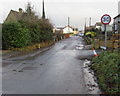
7
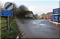
Unsuitable route for wide vehicles, Woodside Lane, King's Stanley
The road ahead on the left is unsuitable for vehicles wider than 6' 6" (nearly 2 metres). Viewed in December 2017. Dyehouse Field houses on the right did not exist at the November 2011 date of this https://www.geograph.org.uk/photo/3221434 photo.
Image: © Jaggery
Taken: 22 Dec 2017
0.02 miles
9
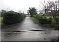
Castle Farm access road, King's Stanley
From Woodside Lane.
Image: © Jaggery
Taken: 22 Dec 2017
0.04 miles
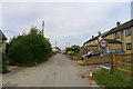
10
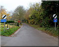
Width restriction on Woodside Lane, King's Stanley
Signs show the end of the 30mph speed limit, a no through road, and a width limit
of 6' 6" (c2 metres) along Woodside Lane, a SW continuation of Castle Street.
Image: © Jaggery
Taken: 20 Nov 2011
0.05 miles