IMAGES TAKEN NEAR TO
Castle Street, STONEHOUSE, GL10 3JY
Introduction
This page details the photographs taken nearby to Castle Street, GL10 3JY by members of the Geograph project.
The Geograph project started in 2005 with the aim of publishing, organising and preserving representative images for every square kilometre of Great Britain, Ireland and the Isle of Man.

There are currently over 7.5m images from over14,400 individuals and you can help contribute to the project by visiting https://www.geograph.org.uk
Image Map
Images are licensed for reuse under creativecommons.org/licenses/by-sa/2.0
Notes
- Clicking on the map will re-center to the selected point.
- The higher the marker number, the further away the image location is from the centre of the postcode.
Image Listing (99 Images Found)
Images are licensed for reuse under creativecommons.org/licenses/by-sa/2.0
Image
Details
Distance
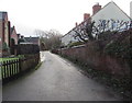
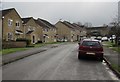
1
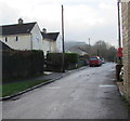
Castle Street, King's Stanley
This part of Castle Street is between the Borough Close junction and the Castle Mead junction.
Image: © Jaggery
Taken: 22 Dec 2017
0.02 miles
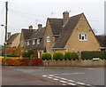
2
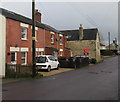
Redbrick houses, Castle Street, King's Stanley
Brunsdon Cottage is on the left.
Image: © Jaggery
Taken: 22 Dec 2017
0.02 miles
3
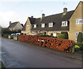
Woodland View, Castle Street, King's Stanley
The name sign in the brown hedge shows WOODLAND VIEW.
Image: © Jaggery
Taken: 22 Dec 2017
0.02 miles
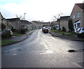
4
Junction of Borough Close and Castle Street, King's Stanley
Borough Close from the right joins Castle Street. High Street is ahead.
Image: © Jaggery
Taken: 22 Dec 2017
0.03 miles
5
Rose Terrace, King's Stanley
From Castle Street, Rose Terrace leads to Ash Close.
Image: © Jaggery
Taken: 22 Dec 2017
0.03 miles
6
Borough Close, King's Stanley
The northwest part of a long cul-de-sac viewed from Castle Street.
Image: © Jaggery
Taken: 22 Dec 2017
0.03 miles
7
Corner of Castle Street and Castle Mead, King's Stanley
Viewed across Castle Street.
Image: © Jaggery
Taken: 20 Nov 2011
0.04 miles
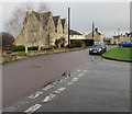
8
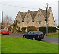
Grade II listed Borough Farm, King's Stanley
Detached house in Castle Street, formerly a farmhouse built in the late 17th century.
Grade II listed in June 1960.
Image: © Jaggery
Taken: 20 Nov 2011
0.04 miles
9
Up Borough Close, King's Stanley
Borough Close ascends from Castle Street.
Image: © Jaggery
Taken: 22 Dec 2017
0.04 miles
10
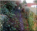
Public footpath in King's Stanley
This public footpath is a track of the northwest side of Castle Street.
Image: © Jaggery
Taken: 22 Dec 2017
0.04 miles