IMAGES TAKEN NEAR TO
Castle Street, STONEHOUSE, GL10 3JX
Introduction
This page details the photographs taken nearby to Castle Street, GL10 3JX by members of the Geograph project.
The Geograph project started in 2005 with the aim of publishing, organising and preserving representative images for every square kilometre of Great Britain, Ireland and the Isle of Man.

There are currently over 7.5m images from over14,400 individuals and you can help contribute to the project by visiting https://www.geograph.org.uk
Image Map
Images are licensed for reuse under creativecommons.org/licenses/by-sa/2.0
Notes
- Clicking on the map will re-center to the selected point.
- The higher the marker number, the further away the image location is from the centre of the postcode.
Image Listing (104 Images Found)
Images are licensed for reuse under creativecommons.org/licenses/by-sa/2.0
Image
Details
Distance
1
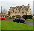
Grade II listed Borough Farm, King's Stanley
Detached house in Castle Street, formerly a farmhouse built in the late 17th century.
Grade II listed in June 1960.
Image: © Jaggery
Taken: 20 Nov 2011
0.01 miles
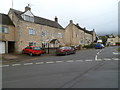
2
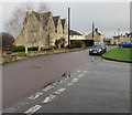
Junction of Borough Close and Castle Street, King's Stanley
Borough Close from the right joins Castle Street. High Street is ahead.
Image: © Jaggery
Taken: 22 Dec 2017
0.02 miles
3
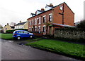
Row of three brick houses, Castle Street, King's Stanley
Located between Borough Close and The Luggs. http://www.geograph.org.uk/photo/5633267
Image: © Jaggery
Taken: 22 Dec 2017
0.03 miles
4
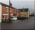
Redbrick houses, Castle Street, King's Stanley
Brunsdon Cottage is on the left.
Image: © Jaggery
Taken: 22 Dec 2017
0.03 miles
5
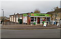
Co-op food store and village post office, King's Stanley
The Co-operative Food store is located on the corner of High Street and Bath Road.
The post office opened inside the store in the spring of 2010. Previously, the village post office was a few metres away, on the opposite side of High Street.
Image: © Jaggery
Taken: 20 Nov 2011
0.03 miles
6
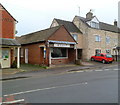
Tony's butchers, King's Stanley
High Street butchers, greengrocery and delicatessen.
Image: © Jaggery
Taken: 20 Nov 2011
0.03 miles
7
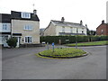
A really mini roundabout
The junction of Castle Street and High Street is marked by a small but grassed roundabout, topped with traffic signs.
Image: © Neil Owen
Taken: 7 Feb 2023
0.04 miles
8
Borough Close, King's Stanley
The northwest part of a long cul-de-sac viewed from Castle Street.
Image: © Jaggery
Taken: 22 Dec 2017
0.04 miles
9
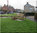
Wooden bench on the green at the edge of High Street, King's Stanley
The bench was presented to the village by Tea and Chatter in 2016 to commemorate the 90th birthday of Queen Elizabeth II. The Tea and Chatter group meet on the first and third Wednesday each month at the King's Head pub in King's Stanley, supporting different charities at each meeting.
Image: © Jaggery
Taken: 22 Dec 2017
0.04 miles
10
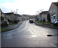
High Street houses, King's Stanley
Houses on the east side of High Street between the Bath Road
junction near the camera and the Shute Street junction ahead.
Image: © Jaggery
Taken: 20 Nov 2011
0.05 miles